


A HIGH WIND WARNING has been issued for the East Glacier area, Rocky Mountain Front, and parts of central Montana through Tuesday.
A WINTER WEATHER ADVISORY is in effect for parts of the Continental Divide and just west of the Divide into Tuesday morning.
A WINTER WEATHER ADVISORY has been issued for the Rocky Mountain Front and the Glacier area for Tuesday through Wednesday.
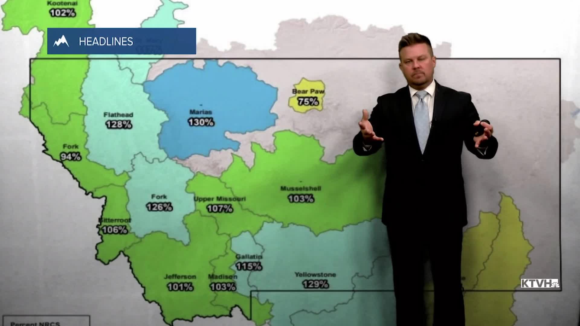
Strong, cold wind that's typical for January will blow across the state this week. A little snow will fall in the lower elevations with the mountains picking up much, much more. There could be up to a couple feet of snow in the mountains this week, but no more than a couple inches in the lower elevations. So while it seems there is no snow, and there's not much in the lower elevations, most of the mountain snowpack in Montana is above average. A weak front moving through Montana into Tuesday morning will deliver a little light snow, especially on the Divide and around the Helena area. Up to 1-2" could accumulate in the higher terrain around the capital. Tuesday will be a mostly cloudy and blustery day for most of the lower elevations. Snow will increase through the day in the mountains. Highs will range from the 30s and 40s in the lower elevations, to the 20s in the mountains. Wind will be gusty along the Rocky Mountain Front and across the plains. Sustained wind will be between 30-40mph, with gusts up to 85mph around East Glacier and the Rocky Mountain Front. Snow will continue in the mountains through Tuesday night. A burst of snow is likely around the Helena area on Wednesday morning as a cold front passes. The plains will only see a few scattered snow showers. Snow will fly in the mountains on Wednesday, but the lower elevations will be partly cloudy with just a few snow showers. It will be windy with highs in the 30s and low 40s, temperatures will fall into the 20s by afternoon and evening. Thursday will be partly cloudy, windy, with snow showers mainly in the mountains. Temperatures will be close to normal. Friday will turn mostly cloudy with strong wind across the plains. Highs will be in the 20s and 30s, with a few spots in the plains hitting the low 40s. This weekend will be partly cloudy with temperatures again turning mild. Highs will reach the 40s and 50s across some of the plains, 30s to around 40 in the valleys, and 20s and 30s in the mountains. The wind will be strong over the Continental Divide and the plains. Right now, there does not appear to be any arctic air or heavy snowstorms through at least the middle of January. There's plenty of winter left...
Have a nice day,
Curtis Grevenitz
Chief Meteorologist
