


A BLIZZARD WARNING has been issued for the Rocky Mountain Front, East and West Glacier areas into Thursday.
A HIGH WIND WARNING has been issued for most of Montana through Thursday afternoon.
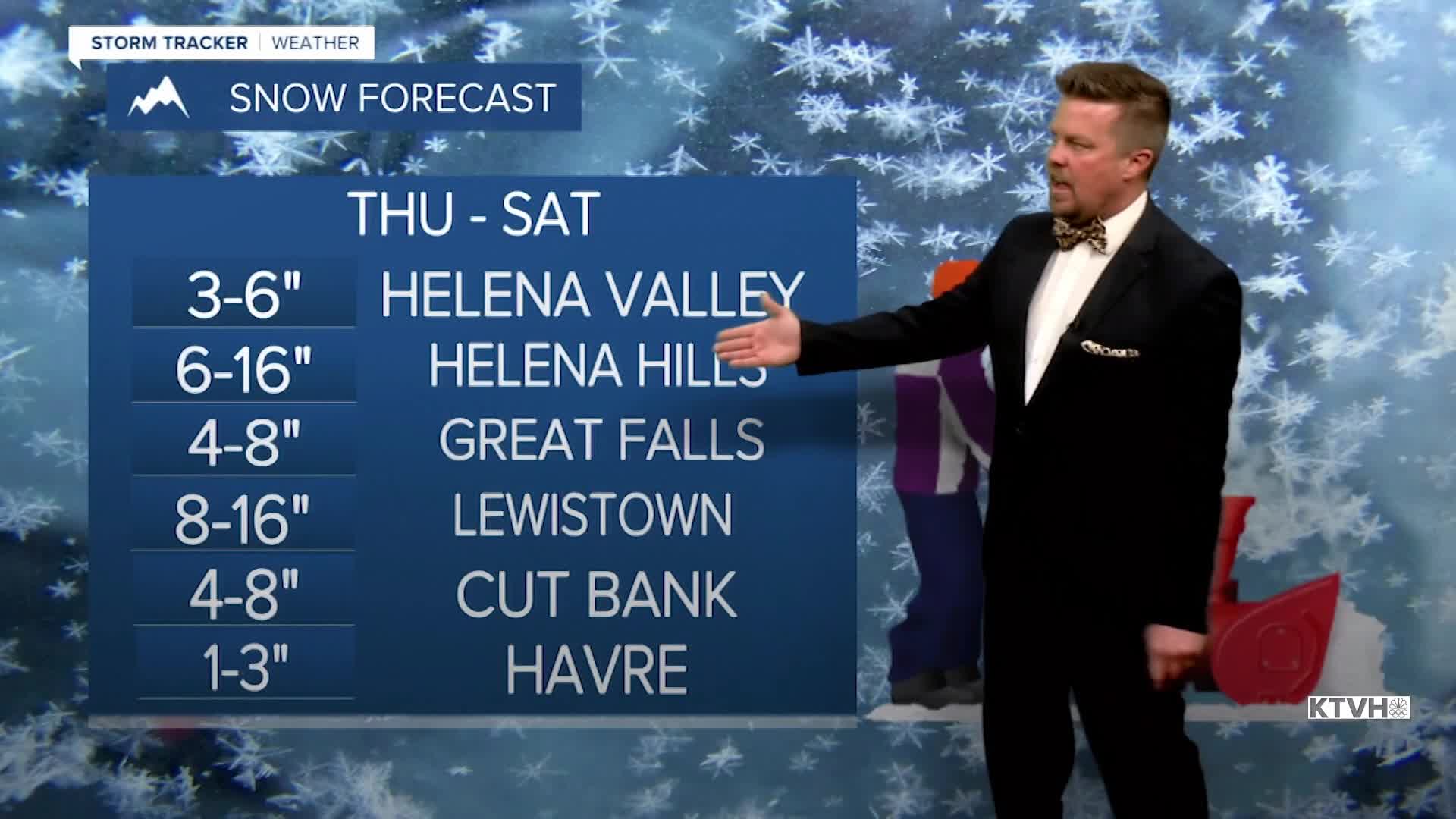
A WINTER STORM WARNING has been issued for the Rocky Mountain Front, Glacier area and down the Continental Divide through Saturday.
A WINTER STORM WATCH has been issued for parts of central and northern Montana from Thursday through Saturday.
An AVALANCHE WATCH has been issued for the western mountains.
A major wind and snow storm will hit the state over the next several days with powerful gusts and then heavy snow, with some mountains seeing blizzard conditions.
The worst of this storm will produce wind up to 95mph along the Rocky Mountain Front and snow of up to 48" in the mountains. The majority of the state will not see those conditions, but everywhere will have powerful wind and eventually some snow. The first part of this storm will be the wicked wind with the strongest gusts Thursday morning into early Thursday afternoon. The wind will slowly ease down through Thursday evening. Thursday will have some highs in the 50s and 60s south, with 30s and 40s north. A cold front will move south with the most powerful wind and some rain changing to snow through the morning hours. The mountains will continue to see very heavy snow through the day, with blizzard conditions creating whiteouts for periods of time. Snow will turn steady around the Helena area through the day. Friday will be cloudy with areas of snow continuing around Helena and redeveloping near Great Falls. The snow will slowly accumulate throughout the day. Heavy snow will continue in the mountains. The wind will be much lighter. A cold front will move south through the state on Friday night into Saturday with all areas picking up snow. Saturday will be a wintry day with highs in the 10s and 20s, and wind of up to 20-30mph blowing around the snow. Several inches will fall in the lower elevations. By this time, several FEET of snow will accumulate in the mountains. Snow will come to and end through Saturday night. A few lingering snow showers are possible on Sunday. Sunday night into Monday, a warm front will move through with some snow initially, followed by rising snow levels through Monday. A major warmup is on the way and temperatures could warm to between 60-70 degrees by St. Patrick's Day. Wild, wild weather.
Be safe out there,
Curtis Grevenitz
Chief Meteorologist
