A WINTER STORM WARNING continues into Tuesday morning for the higher terrain west of the Continental Divide including Macdonald Pass.
A WINTER WEATHER ADVISORY continues into Tuesday morning for East Glacier, the Rocky Mountain Front, and the mountains of central and southern Montana.
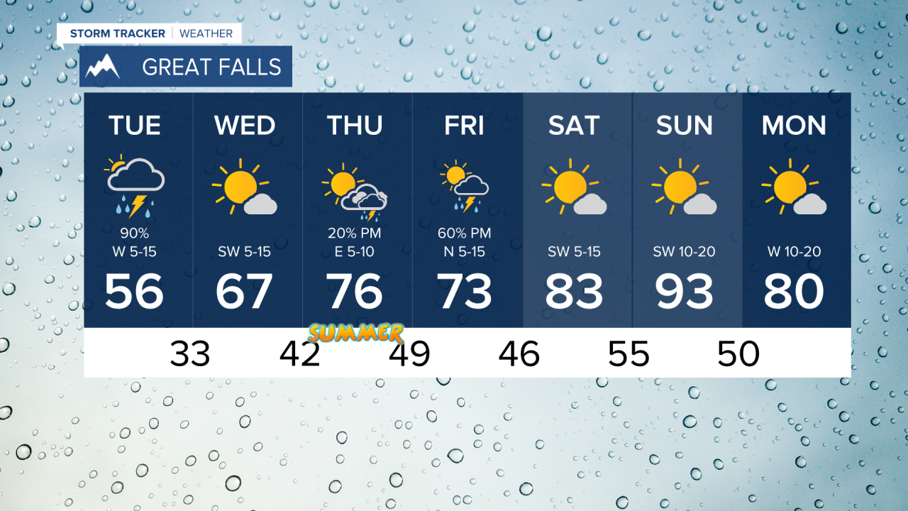
This is a beautiful storm for Montana with a soaking rain in the lower elevations and a blanket of snow in the mountains, and the storm is certainly not over with yet. Summer officially begins on Thursday and hot temperatures are not far off. This storm is a blessing and will continue to produce rain and higher elevation snow through Monday night and Tuesday. Snow levels will once again drop below pass level so some passes will be slippery Tuesday morning. Areas of rain will continue with the heaviest shifting into eastern Montana by daybreak. Tuesday will be another stormy day with showers, thunderstorms, higher elevation snow, and a little sun mixed in there too. Temperatures will be chilly with highs in the 50s, some 40s in the mountains. Some strong to severe thunderstorms are possible in eastern Montana late in the evening. Most of the wet weather will move out Tuesday night and temperatures will get chilly. Many areas will wake up on Wednesday in the 30s with a chance of a frost. The final day of spring will be warmer with mostly sunny skies. Highs will top out in the 60s and 70s. Thursday is the first day of summer and highs will warm into the 70s to near 80. A few isolated thunderstorms are possible in the afternoon. Friday will have more thunderstorm activity across the state with highs in the 70s. The first weekend of summer will be a toasty one with highs in the 80s on Saturday. Sunday will be the hottest day of the year so far with temperatures reaching the 80s and 90s. An isolated storm is possible in the Sunday afternoon heat. A weak and dry cold front will go through Sunday night with Monday cooling back off into the 70s and 80s.
Enjoy the rain!
Curtis Grevenitz
Chief Meteorologist


