A SEVERE THUNDERSTORM WATCH is in effect until 9pm Tuesday for western and southwestern Montana. Severe thunderstorms with damaging wind gusts (gusts up to 70 mph) are expected. Severe thunderstorms with large hail (up to 1” in diameter) are also possible.

A HIGH WIND WARNING is in effect for portions of north-central Montana from 6am/10am Wednesday until 12pm Thursday. Sustained wind speeds are going to be between 25 and 40 mph, and wind gusts up to 60 mph are possible.

A RED FLAG WARNING is in effect for portions of northeastern Montana and eastern portions of north-central Montana until 1am Wednesday. Critical fire weather conditions are currently occurring due to the combination of hot temperatures, gusty winds, and low relative humidity.

A LAKE WIND ADVISORY is in effect for Fort Peck Lake from 8pm Tuesday until 9pm Thursday. Sustained wind speeds are going to be between 20 and 30 mph, and wind gusts up to 45 mph are possible.

Showers and thunderstorms are likely in central and western Montana this evening and tonight as a cold front passes through our area. Some of these thunderstorms may also be severe with damaging winds (wind gusts up to 70 mph) being the main hazard, but isolated large hail (up to 1” in diameter) is also possible. We are also going to have partly cloudy skies tonight, and it will continue to be hazy tonight in northeastern Montana.

Also, as the cold front passes through, a period of gusty winds (gusts up to 40 mph) is expected. Outside of that, it will be breezy tonight in eastern portions of north-central Montana, and the wind will increase later on tonight in locations along and just east of the Continental Divide. It is also going to be cool/mild tonight as lows are going to be in the 50s and 60s.
For tomorrow and tomorrow night, it is going to be a very windy day as sustained wind speeds are going to be between 15 and 35 mph, and widespread wind gusts between 35 and 50 mph are expected. Some locations may even see wind gusts up to 60 mph at times tomorrow and tomorrow night. Also, this wind is going to be coming out of the west or the west-southwest in most locations. It is also going to be a lot cooler tomorrow than it was today in central Montana as highs are going to be in the 60s and 70s. In eastern Montana, it will be cooler tomorrow than it was today, but it is still going to be warm as highs are going to be in the 80s.
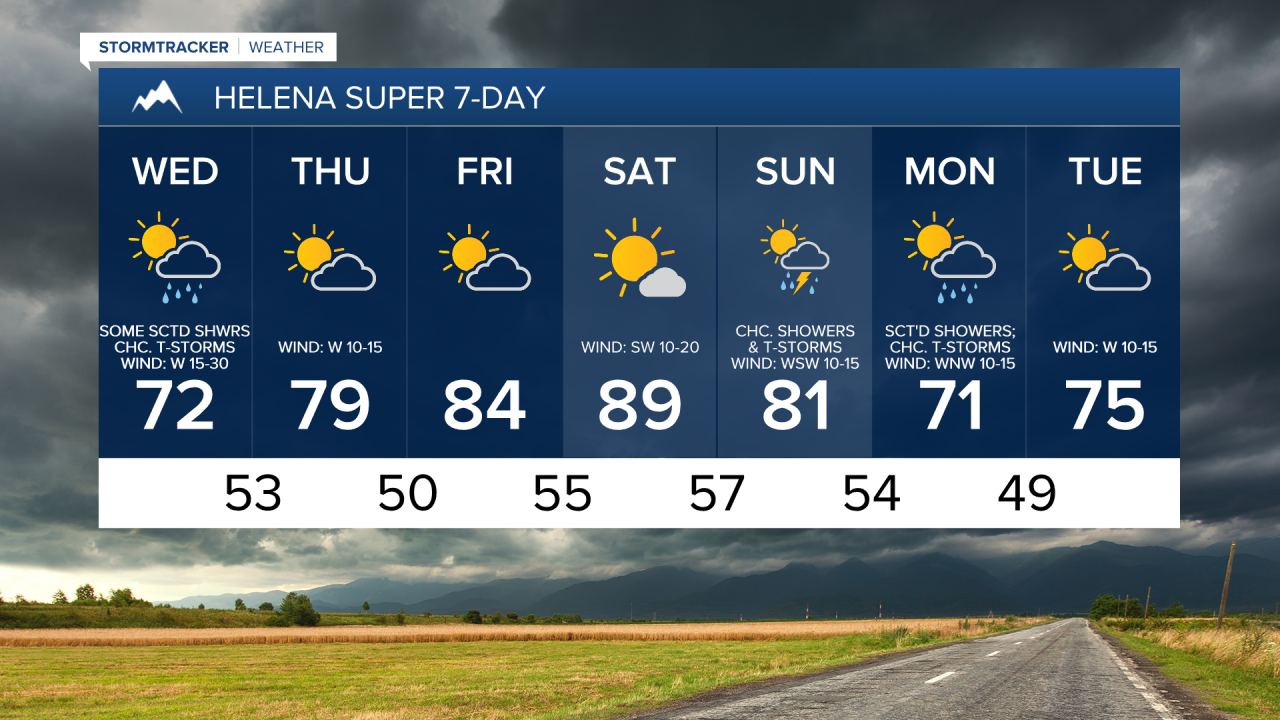
There are also going to be scattered showers and a few thunderstorms around tomorrow, especially during the afternoon/evening, and tomorrow night as a storm system slowly works its way through our area. We are also going to have partly cloudy skies tomorrow, with increasing clouds during the afternoon and evening. We are then going to have mostly to partly cloudy skies tomorrow night.
On Thursday, we are going to have partly cloudy skies with a few scattered showers and isolated thunderstorms around, generally during the morning and generally in locations east of I-15 in north-central Montana, as tonight/tomorrow’s storm system finally departs our area. We are also going to have gusty winds around on Thursday as sustained wind speeds are going to be between 10 and 30 mph, and wind gusts over 40 mph are possible. It is also going to be mild/warm on Thursday as highs are going to be in the mid to upper 70s and low 80s in most locations.
Partly cloudy skies and mostly dry conditions are then expected on Friday, and mostly sunny skies and mostly dry conditions are expected on Saturday as high pressure is going to be in control of our weather. The temperatures are also going to warm up some over these two days as highs are going to be in the 80s on Friday and the mid to upper 80s and low to mid 90s on Saturday. It is also going to be breezy on Saturday as sustained wind speeds are going to be between 10 and 25 mph.
On Sunday, we are going to have increasing clouds with some isolated showers and thunderstorms around, generally during the afternoon/evening and generally in the mountains. There are then going to be some scattered showers and a few thunderstorms around on Monday (Labor Day) as a storm system works its way through our area. We are also going to have partly cloudy skies on Sunday. The temperatures are also going to cool down some over these two days as highs are going to be in the 80s on Sunday and the 70s and mid to upper 60s on Monday. It is also going to be breezy on these two days as sustained wind speeds are going to be between 10 and 20 mph.