

There are going to be some scattered rain showers and thunderstorms around this evening and early tonight, generally in locations south and west of Great Falls, as some monsoonal moisture works its way into our area. We are also going to have partly to mostly cloudy skies around this evening, then we are going to have decreasing clouds tonight. For tomorrow, we are going to have increasing clouds throughout the day with some scattered rain showers and thunderstorms around during the afternoon and evening as an upper-level trough sends some moisture into our area. Also, most of the thunderstorms that do develop today and tomorrow are going to be non-severe, although frequent lightning, heavy rainfall, gusty winds, and small hail are still possible with any thunderstorms that do develop.
As we head into this weekend, there is a slight chance that we could see a couple rain showers and thunderstorms during the PM hours, but most locations are going to remain dry. We are also going to have mostly to mainly sunny skies this weekend.
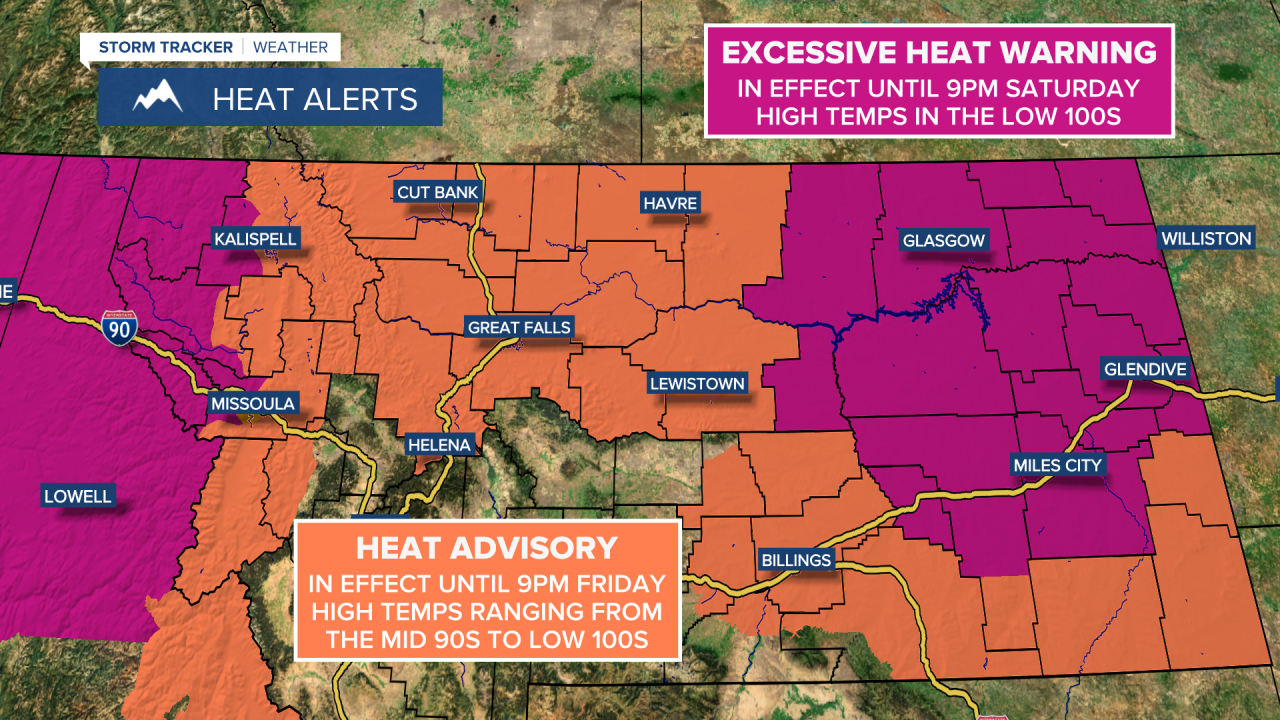
It is also going to continue to be very hot tomorrow and this weekend as high temperatures are going to continue to be in the mid to upper 90s and low 100s in most locations. Because of this heat, a Heat Advisory remains in effect for central Montana until 9pm tomorrow, and an Excessive Heat Warning remains in effect for eastern Montana until 9pm on Saturday. Thankfully, even though it is going to be hot during the day, at least we are going to continue to get some relief from the heat at night as lows are generally going to be in the upper 50s and low to mid 60s for the next four nights.
For this evening, tonight, tomorrow, and Saturday, it is going to be breezy in eastern Montana as sustained wind speeds are going to be between 10 and 20 mph. It is also going to be a little breezy tonight and Saturday along the Hi-Line as sustained wind speeds are going to be between 10 and 15 mph. Due to this wind, there is a Lake Wind Advisory in effect for Fort Peck Lake until 1am tomorrow morning. There is also a Red Flag Warning in effect until 9pm tomorrow for most locations east of Great Falls as critical fire weather conditions are expected.

As we head into next week, it is going to continue to be hot, although it will be slightly cooler than it is going to be tomorrow and this weekend as highs are going to be in the upper 80s and low to mid 90s. It is also going to continue to be mild at night next week as lows are going to be in the mid to upper 50s and low 60s in most locations. There is also going to be a bit of a breeze around on Tuesday, Wednesday, and Thursday of next week in central Montana as sustained wind speeds are going to be between 10 and 15 mph. In eastern Montana, it is going to be breezy all of next week as sustained wind speeds are going to be between 10 and 20 mph. We are also going to continue to have mostly to mainly sunny skies and mostly dry conditions next week as high pressure is going to continue to be in control of our weather.


