


Good Morning and Happy Labor Day! Today is Monday, September 7, 2026. Here is today’s forecast:
Scattered showers and thunderstorms moved through yesterday evening and overnight. Several storms became severe, producing large to very large hail and strong winds. The largest hailstone reported in north-central Montana was about 2.5” in diameter and fell near Hilger in Fergus County.

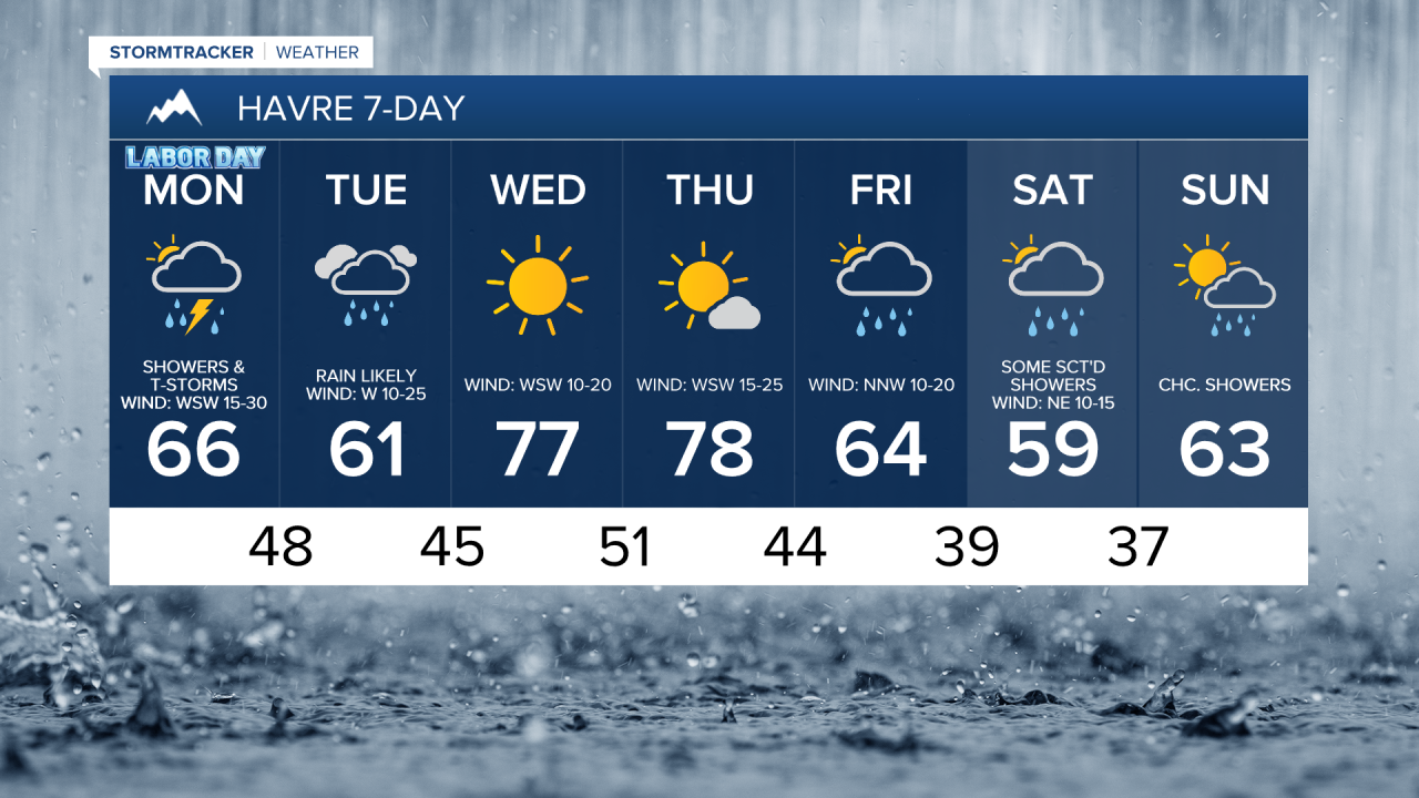
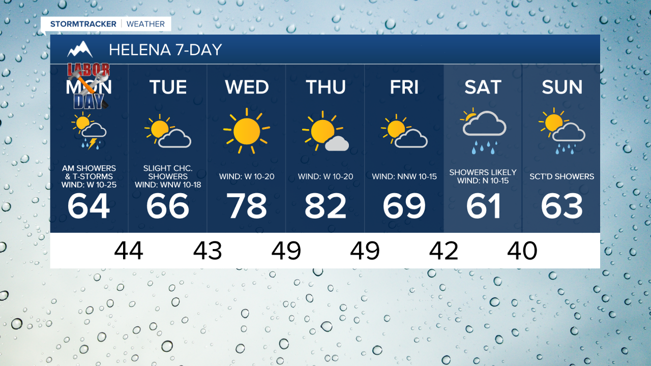
It will be a wet start to the week as a storm system continues to impact Montana. Showers and thunderstorms are likely today, especially during the morning hours. Scattered showers and a few thunderstorms will continue tonight and tomorrow, primarily across north-central Montana.
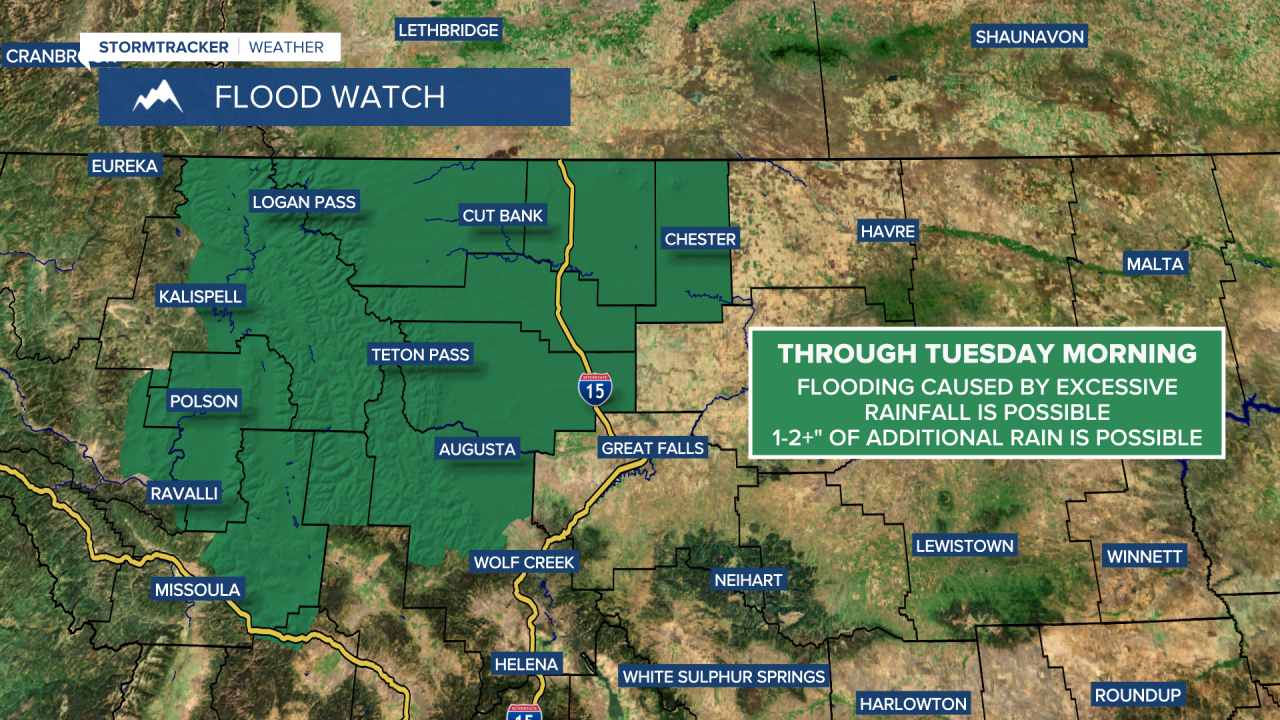
Rainfall totals will vary considerably across the region. Along the Rocky Mountain Front, along portions of the Hi-Line from the Continental Divide through Hill County, and across parts of the Golden Triangle, an additional 1 to 2+ inches of rain is expected through tomorrow night. Elsewhere across north-central Montana, most locations will receive between 0.25 and 0.75 inches of additional rain, though some areas may see higher or lower amounts. Around the Helena area, many locations are expected to receive less than 0.25 inches of additional rain through tomorrow night.

A FLOOD WATCH is in effect for portions of western and north-central Montana through Tuesday morning. Flooding due to excessive rainfall is possible in these areas as 1-2+” of additional rain is expected.
Cloud cover will vary across the state today. Mostly cloudy skies are expected in some areas, while Helena and southern and eastern portions of north-central Montana will see partly cloudy skies, with gradual clearing as the day progresses. Partly to mostly cloudy conditions will continue tonight and Tuesday.
Winds will increase throughout the day, becoming gusty this afternoon and evening. Sustained winds of 15 to 30 mph are expected, with gusts reaching 40 to 50 mph. Gusty conditions will continue tonight, especially across north-central Montana, where gusts over 40 mph will remain possible at times. Winds will ease somewhat on Tuesday, but breezy conditions will persist with sustained speeds of 10 to 25 mph and gusts up to 40 mph.
It will be a cool start to the week as highs today and tomorrow are going to be in the mid to upper 50s and low to mid 60s in most locations. Northeastern Montana will be warmer today, with temperatures reaching the low to mid 70s.
Beautiful weather returns Wednesday and Thursday as high pressure takes control. Wednesday will be sunny and dry, while Thursday will be partly to mostly sunny with mainly dry conditions. Temperatures will also warm, with highs climbing into the 70s and low to mid 80s. Wednesday will be breezy, with sustained winds of 10 to 25 mph. Thursday looks windier, with sustained winds of 15 to 35 mph and gusts may exceed 50 mph at times.
A cold front will bring cooler temperatures back on Friday, with highs returning to the mid to upper 50s and low to mid 60s. Skies will be partly to mostly cloudy, and a few showers are possible, generally in the mountains and along the Hi-Line. It will also be a little breezy on Friday as sustained wind speeds are going to be between 5 and 20 mph.
Another storm system will impact the state this weekend. There will be scattered showers around throughout the weekend, but especially on Saturday. In the mountains, temperatures may become cold enough for accumulating snow, with snow levels potentially dropping to pass level, around 5,000 to 6,000 feet, Saturday night into Sunday morning. High temperatures this weekend will generally be in the 50s and low to mid 60s.


Have a great Labor Day!
Chief Meteorologist Ryan Dennis
