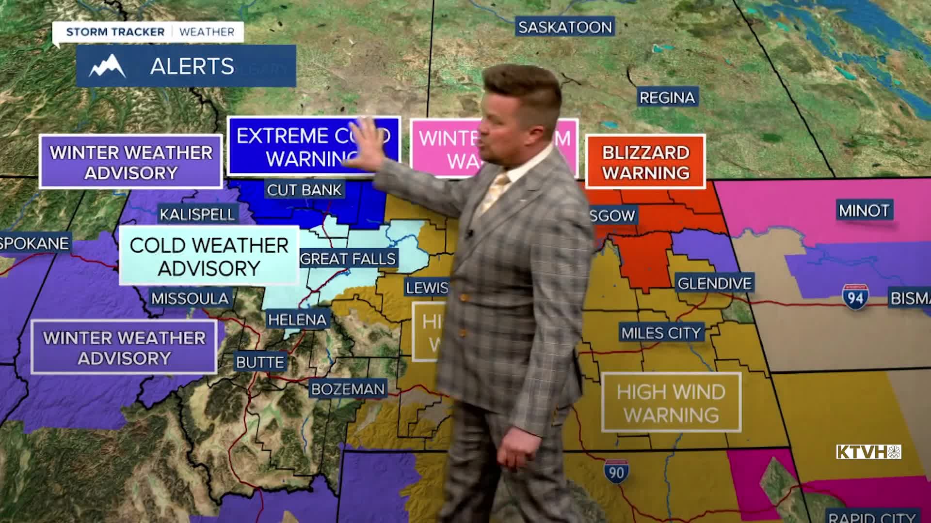


A BLIZZARD WARNING continues for northeast Montana until Wednesday 5pm.
A WINTER STORM WARNING continues for northern Blaine County until 11pm.
An EXTREME COLD WARNING has been issued for the East Glacier area into Wednesday.
A COLD WEATHER ALERT has been issued for parts of the Hi-Line through Great Falls to near Helena into Wednesday.
A HIGH WIND WARNING continues for parts of central Montana this evening.
A WINTER WEATHER ADVISORY continues for parts of the Hi-Line this evening.
Just in case you forgot what season is, winter reminded everyone on Tuesday with snow, wind and arctic air. From thundersnow to blizzard conditions, a powerful storm continues to work across the state. Most of the snow has moved into northeast Montana where blizzard conditions tonight through Wednesday will create treacherous travel and whiteout conditions. Arctic air continues to work into the state and temperatures will tumble through late Tuesday into Wednesday as readings drop to the -0s and 0s for most. Wind chills will be as cold as -40 near Cut Bank and East Glacier, with -30 wind chills possible elsewhere on the Hi-line, around Great Falls, the Rocky Mountain Front and near Helena. Wednesday will be a cold and cloudy day with areas of light snow. There could be another 1-2" from this snow. Highs will be in the -0s to 10s range for most of Montana. Thursday will be partly cloudy and cold with some snow showers. Any accumulation will be light. Highs will be in the 0s up north, 10s and 20s elsewhere. Friday will be another partly to mostly cloudy day with areas of snow showers through the afternoon. Highs will stay cold in the 10s and 20s. The snow should come to an end this weekend with high pressure moving in. Saturday will be partly to mostly sunny with highs in the 10s to near 30. Sunday will be mostly cloudy with highs in the 10s to low 30s. Monday will be briefly warmer as a southwest wind pushes out the arctic air. There's a chance of some light snow or a rain/snow shower later in the day. Tuesday will be blustery with areas of light snow. The rest of February into March should be active with numerous storms, bringing much needed precipitation, and the mountains should at least get typical snow for the time of year.
Stay warm,
Curtis Grevenitz
Chief Meteorologist
