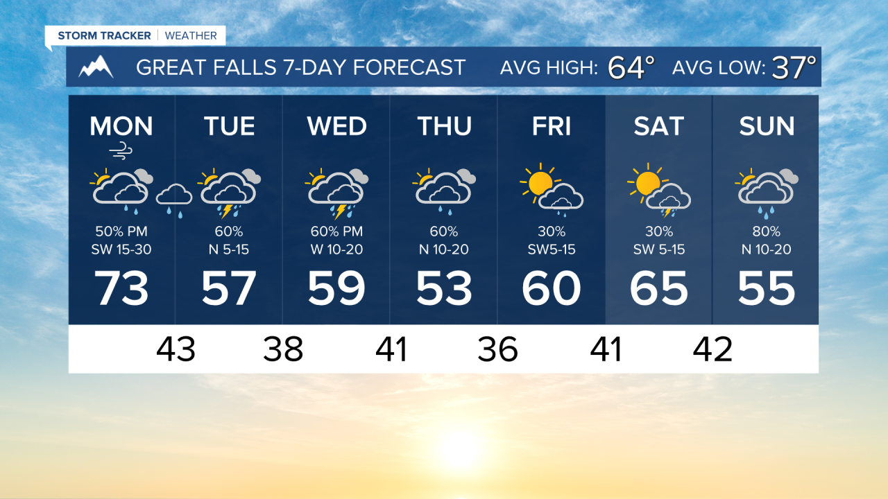
It's going to be a busy weather week across the state on Montana. It begins today with rain across southwestern Montana late this afternoon. Rain will fall around the Butte/Helena/Bozeman areas overnight and through tomorrow morning. Snow levels will drop to about 6-7 thousand feet. Highs will vary across the state from the lower 60s to the low 90s. Cooler weather in the west, and hotter in the east.
Highs for the remainder of the week will only reach the 50s and 60s for most of the area. Showers and thunderstorms will be around daily. It will be a soggy week for most.
The mountains of southern Montana could receive 1-2 feet of snow Tuesday through Thursday.
Another larger-scale storm system is expected to come into the state on Sunday. As of the current forecast, this will bring significant precipitation.
——————————————————————————————————————————
WEATHER ALERTS:
A RED FLAG WARNING has been issued for northeast Montana from 11 AM Monday until 9 PM Monday
A WINTER WEATHER ADVISORY has been issued for the Mountains of Southwestern Montana south of Interstate 90, and Elkhorn and Boulder Mountains from 8 PM Monday until 9 AM Tuesday
A WINTER STORM WATCH has been issued for the Absaroka/Beartooth Mountains from Tuesday morning until Thursday evening
A WINTER STORM WATCH has been issued for the Pryor/Northern Bighorn Mountains from Tuesday evening until Thursday evening
——————————————————————————————————————————
Helena Temperature Records Today:
High: 92 (2001)
Low: 22 (1943)
AVG: 65/40
Great Falls Temperature Records Today:
High: 90 (2001)
Low: 22 (1943)
AVG: 64/37
Have a great Monday!
Joey Biancone
Meteorologist