


A WINTER WEATHER ADVISORY has been issued for the Elkhorn and Boulder Mountains, as well as MacDonald Pass, through 6 PM Saturday.
A WINTER STORM WARNING continues for the Centennial, Madison, and Gallatin Mountains through 6 PM Saturday.
A WINTER STORM WARNING continues for the Crazy, Absaroka, and Beartooth Mountains through 6 AM Sunday.
A WINTER WEATHER ADVISORY continues for the Ruby and Beaverhead Mountains through 6 PM Saturday.
A RED FLAG WARNING continues for northeast Montana through 8 PM tonight.
——————————————————————————————————————————
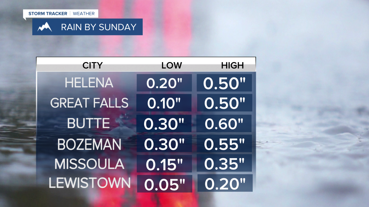
Rain showers will last through Saturday evening for the western half of the state. A band of rain is expected to set up close to Helena tomorrow that could be responsible for totals up to half an inch.
We saw the sun briefly in the capital today, allowing slightly warmer temperatures than expected. We hit a high around 59°. Rain and snow showers are present as the writing of this article in most of western and central Montana. We actually have a rare easterly flow aloft that will bring some showers close to Helena by tonight.

Tomorrow will be a little cooler due in part to the rainfall being present and more consistent cloud cover in the mountainous regions. Temperatures will be in the mid 40s to mid 50s. Southwest flow will return to the plains tomorrow afternoon, allowing warmer daytime high temperatures. Upper 50s to low 60s is expected.
A heavier band of rain is expected to set up close to Helena and Great Falls in the late morning tomorrow and last through the PM hours. depending on the strength of the flow aloft, the positioning of this band could fluctuate before it changes directions and heads back east. Where this band sets up will greatly alter rainfall amounts for locations in central Montana.
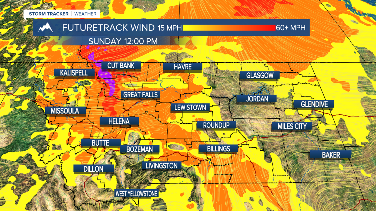
Most of the rain will be gone by Sunday morning. Just some isolated showers in the higher terrain of western Montana. With our upper level flow changing back out of the west, expect strong winds to develop off the Rocky Mountain Front. Gusts over 55 MPH are possible along the front and the adjacent areas. We will warm slightly back into the low 60s.
A cold front will move through the state during the day on Monday. Strong wind, in addition to numerous showers and thunderstorms are possible along and behind this front. It is looking like the potential for strong wind gusts is highest this day. High Wind alerts may be issued this weekend. Helena and Great Falls could have sustained winds of 30+ MPH.
Additionally, models are hinting at another upper level trough that enters the state on Monday. This will prevent us from warming further and actually cool most of western Montana back below average into the 50s.
Snow showers for the higher terrain of western Montana is becoming more likely Monday night through Wednesday morning of next week. It is still very early, but models are hinting at the rain/snow line dropping to between 2000 and 4000 feet for that time frame. For reference, the Helena Regional Airport sits at 3874 feet.
Unsettled weather will stick around until at least next weekend.
Helena Temperature Records Today:
High: 84° (1910)
Low: 21° (1961)
AVG: 60/35
Great Falls Temperature Records Today:
High: 88° (1910)
Low: 19° (1960)
AVG: 58/32
Have a good weekend!
Joey Biancone
Meteorologist
Facebook: Meteorologist Joey Biancone
Instagram: joeybianconewx
Email: joey.biancone@ktvh.com
