


Colder-than-normal temperatures are locked in for Montana over the next few days. Make sure to bundle up before heading outside.
THURSDAY, JANUARY 22ND: A cold front is expected to move through the state this afternoon through Thursday evening. It will only get as warm as the 20s before temperatures drop significantly heading into Friday morning.
Mostly cloudy skies will be around for most of north-central Montana, while partly cloudy skies can be expected near the Helena area.
Snow flurries are possible once the front reaches the mountains, bringing a north wind to upslope on the Rocky Mountain Front, Big Belts, and Little Belts. Accumulation will be less than one inch for areas near the mountains in the north-central plains.
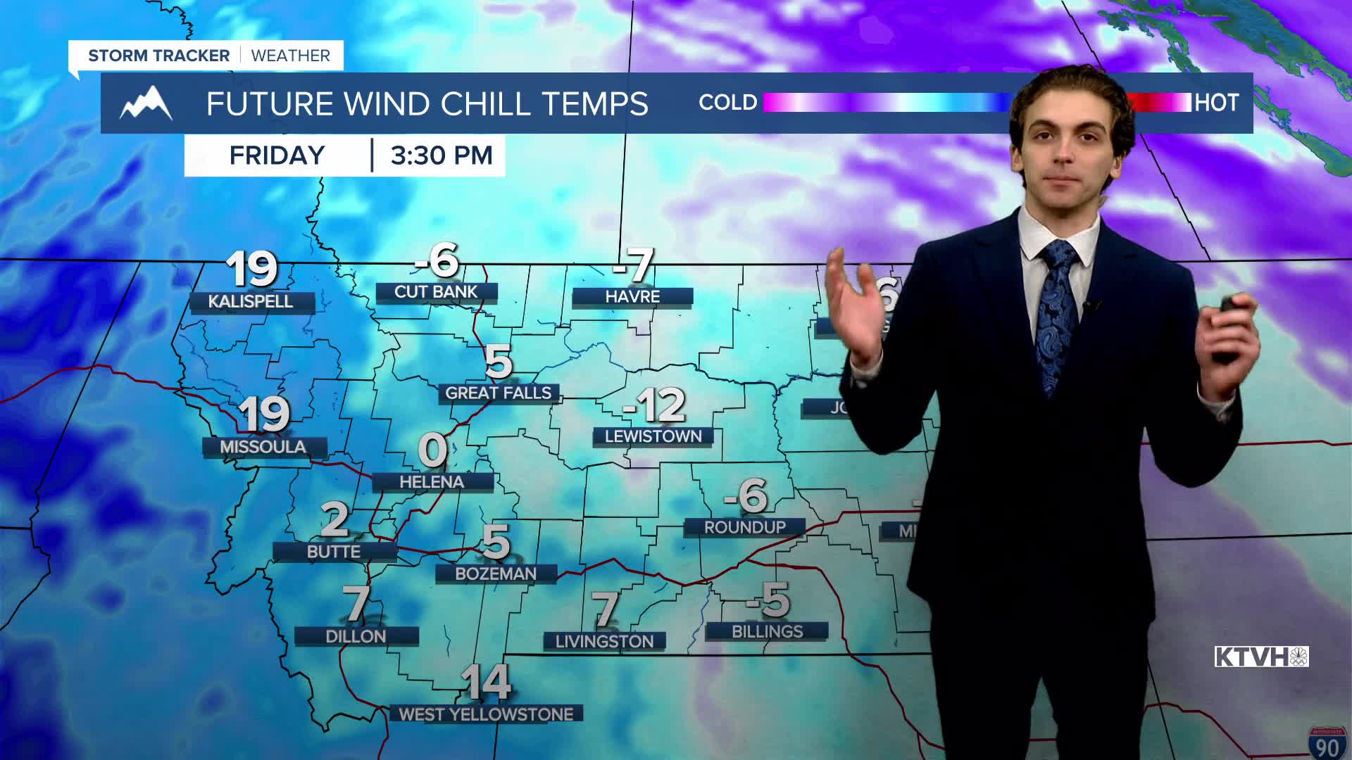
FRIDAY, JANUARY 23RD: The coldest air of the season so far will be here in the morning. Lows dropping below zero in the morning for many across the state. Wind chills could dip down to -45° in northeast Montana. Wind chills in the Helena and Great Falls areas will be in the -0s, -10s, and potentially the -20s at times. High's will only reach the single digits for most. Make sure you bundle up well if you're going to be outdoors.
SATURDAY, JANUARY 24TH: It is becoming increasingly likely that some light snow will fall in the plains adjacent to the Rocky Mountain Front on Saturday. There may be some locally heavier amounts of several inches in areas near the central island mountain ranges and the Little Belt Mountains.
Temperatures will be at or near zero yet again in the morning, only warming into the teens and 20s by the afternoon.
SUNDAY, JANUARY 25TH: Clouds will clear out by Sunday morning. West wind will begin to pick up off the Rocky Mountain Front, warming Great Falls above freezing. Helena will be stuck in a temperature inversion, so highs will only reach the 20s.
LONG-RANGE FORECAST: Another chance for colder air and snow will arrive by the middle of next week. Details still need to be worked through, but generally expect below normal temperatures with at least some light mountain snow.
——————————————————————————————————————————
WEATHER ALERTS:
A EXTREME COLD WARNING continues for Daniels, Northern Valley, Richland, Sheridan, and Roosevelt Counties until 1 PM Sunday
A COLD WEATHER ADVISORY continues for Phillips, Central and Southern Valley, Dawson, Garfield, McCone, Prairie, and Wibaux Counties until 1 PM Sunday
A COLD WEATHER ADVISORY has been issued for Carter, Custer, Fallon, and Northern Rosebud Counties from 3 PM Thursday until 10 AM Friday
A COLD WEATHER ADVISORY has been issued for Bears Paw Mountains and Southern Blaine, Hill County, and Northern Blaine County from 5 PM Thursday until 10 AM Friday
A WINTER WEATHER ADVISORY has been issued for Portions of central, south central, and southeast Montana from 5 PM Thursday until 5 PM Friday
——————————————————————————————————————————
Helena Temperature Records Today:
High: 55 (1919)
Low: -29 (1962)
AVG: 33/14
Great Falls Temperature Records Today:
High: 62 (1981)
Low: -32 (1982)
AVG: 36/15


