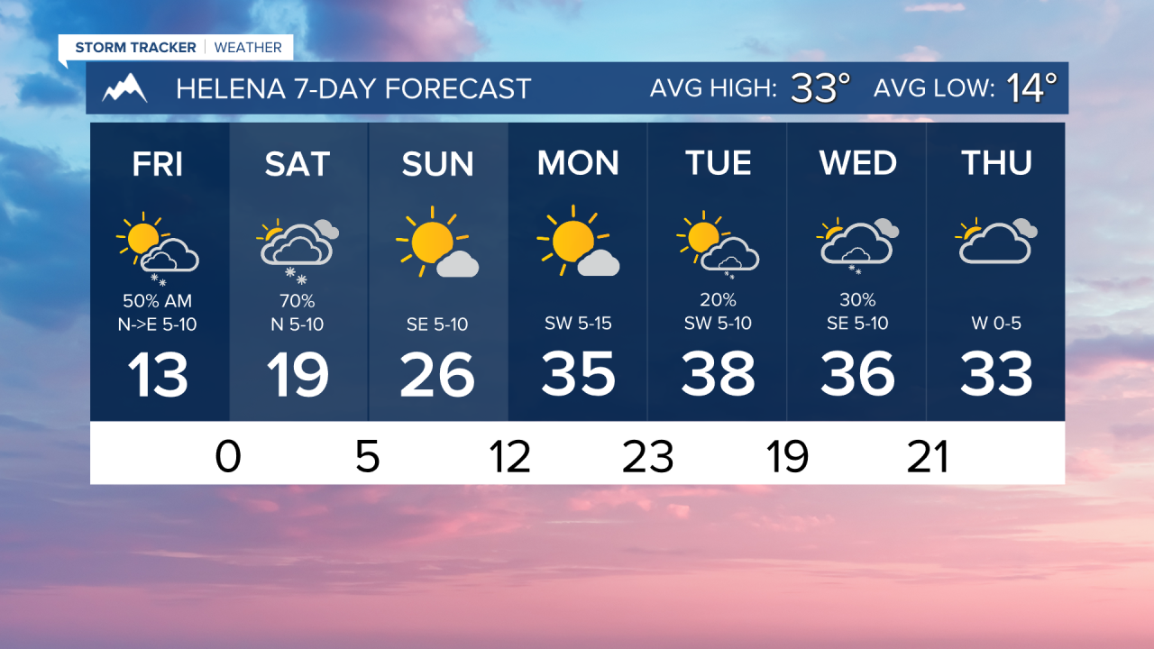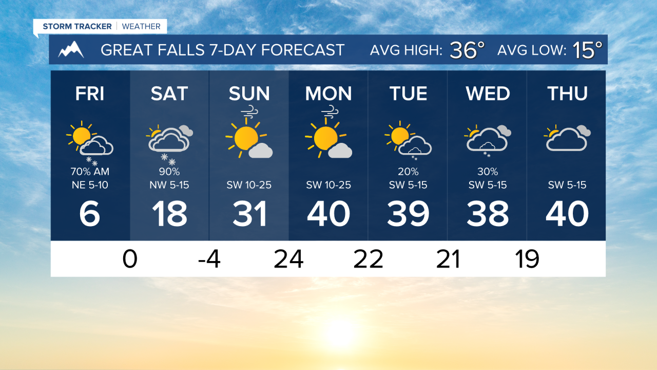


FRIDAY, JANUARY 23RD: The coldest air of the season so far is here this morning. Lows are near or below zero for many areas across the state. Wind chills have dipped down to the -50s° in northeast Montana. Wind chills in Helena and Great Falls are in the -0s, -10s. High's will only reach the single digits and low teens for most. Northeast Montana will not get above zero. Make sure you bundle up well if you're going to be outdoors.
Some flurries are being reported near the Helena and Great Falls areas this morning. They are not being picked up by radar. This will not accumulate too much. The clouds and flurries will be out of our area this afternoon.
SATURDAY, JANUARY 24TH: Morning lows will be near zero for most areas again. Snow will develop as northwest winds move through the plains by morning. This is looking more likely to bring accumulating snowfall to towns like Great Falls, Lewistown, and Helena. I'd expect to see about 1-2 inches around Helena, 1-3 inches in Great Falls, and locally higher amounts in Lewistown, the Snowy Mountains, and the Little Belt Mountains.
High temperatures will only max out in the teens and low 20s under mostly cloudy conditions. Arctic air will still be in place for many, especially in eastern Montana.
SUNDAY, JANUARY 25TH: Another surface high moving through the northeastern plains will reinforce the cold air on Sunday morning. Lows in the plains will dip into the -0s, -10s, and -20s once again. Helena will be in the single digits. High pressure will begin to move southeastward, and by the afternoon, a little west wind will begin to develop along the Rocky Mountain Front. This will assist north-central Montana in warming into the upper 20s to low 30s. It will be colder in Helena, but we will have a mostly sunny day.
LONG-RANGE FORECAST: With a downslope wind developing, it is trending less likely that cold air comes back to the Helena and Great Falls areas by the middle of the week. However, Arctic air will come back at times near the Hi-line and eastern Montana. Most of next week will be dry, aside from an isolated snow shower or two.
——————————————————————————————————————————
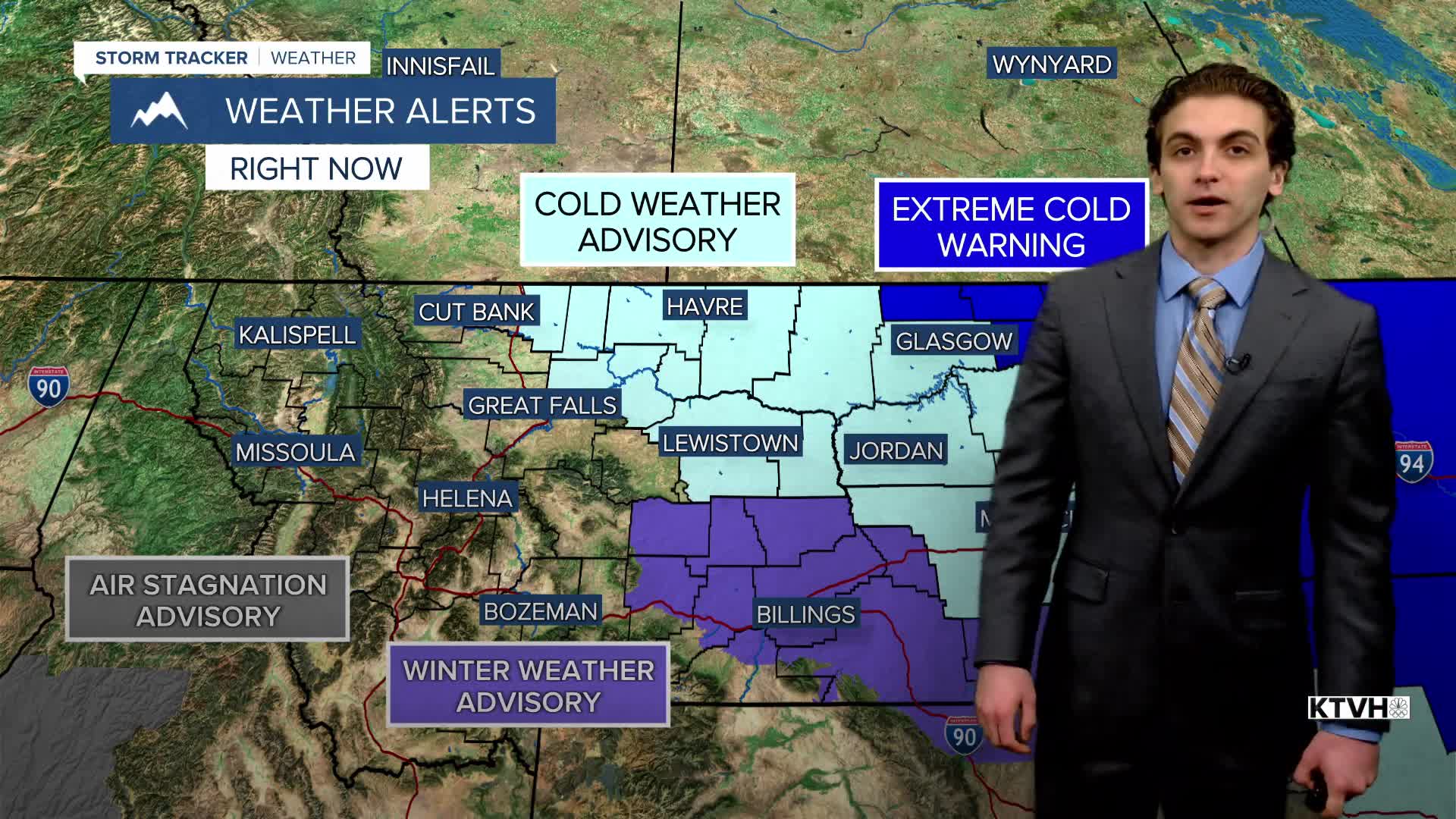
WEATHER ALERTS:
A EXTREME COLD WARNING continues for Daniels, Northern Valley, Richland, Sheridan, and Roosevelt Counties until 1 PM Sunday
A COLD WEATHER ADVISORY continues for Carter, Custer, Fallon, and Northern Rosebud Counties until 10 AM Friday
A COLD WEATHER ADVISORY continues for Eastern Toole and Liberty Counties, Western and Central Chouteau County, Fergus County below 4500ft, and Snowy and Judith Mountains until 11 AM Friday
A COLD WEATHER ADVISORY continues for the Bears Paw Mountains and Southern Blaine, Hill County, and Northern Blaine County until 11 AM Friday
A COLD WEATHER ADVISORY continues for Petroleum County until 11 AM Friday
A COLD WEATHER ADVISORY continues for Phillips, Central and Southern Valley, Dawson, Garfield, McCone, Prairie, and Wibaux Counties until 1 PM Sunday
A WINTER WEATHER ADVISORY continues for Portions of central, south central, and southeast Montana until 5 PM Friday
——————————————————————————————————————————
Helena Temperature Records Today:
High: 56 (1931)
Low: -35 (1969)
AVG: 33/14
Great Falls Temperature Records Today:
High: 63 (2005)
Low: -37 (1969)
AVG: 36/15