


A HIGH WIND WARNING continues for the north-central plains through 7 PM tonight.
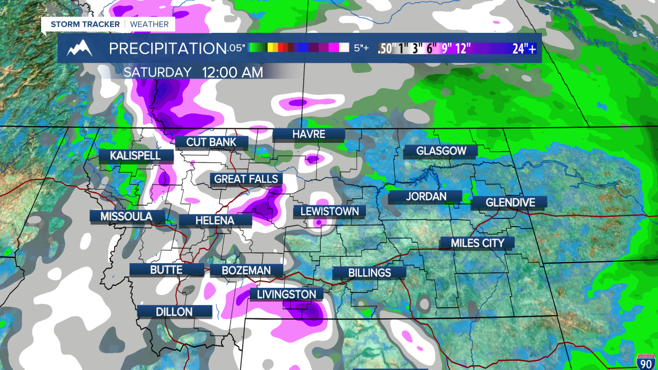
A WINTER STORM WARNING has been issued for the Little Belt and Highwood Mountains from 6 AM Wednesday through 6 PM Thursday.
A WINTER STORM WARNING has been issued for East Glacier and the northern Rocky Mountain Front from 12 AM Wednesday through 12 PM Thursday.
A WINTER WEATHER ADVISORY has been issued for the Big Belt's, Bridger's, Castle's, Snowy's, and Judith ranges from 12 PM Wednesday through 6 PM Thursday.
A WINTER WEATHER ADVISORY has been issued for the high plains and the southern Rocky Mountain Front from 12 AM Wednesday through 12 PM Thursday.
A WINTER WEATHER ADVISORY has been issued for Marias Pass and West Glacier from 4 PM Wednesday through 9 AM Thursday.
A RED FLAG WARNING has been issued for northeast Montana through 8 PM tonight.
A LAKE WIND ADVISORY has been issued for Fort Peck Lake through 9 PM tonight.
——————————————————————————————————————————
All different types of weather alerts affecting many across the state this afternoon as a slow moving storm system causes a variety of weather conditions.
It is a busy weather day today across the state. A lot of shower and storm activity is still ongoing in central and western Montana, as well as strong wind out east. This activity will start to subside overnight tonight before the main event for snow comes in tomorrow night into Thursday.

Colder temperatures have set in to a majority of the state. Helena hit a high of just 50 degrees today. This is about 11 degrees below average for the last day of April. We will be quite chilly tonight, with temperatures dipping down into the upper 20s to low 30s.
There will be some scattered snow showers in the higher terrain once again tomorrow. It is possible for a few flakes or graupel to make its way down to lower elevations. Temperatures will only be in the 40s. Some stronger gusts of wind are possible once again.

Tomorrow night, a heavier batch of snow will make its way southward from Canada on the backside of the departing surface low. This could give lower elevations a quick burst of accumulating snow, but don't expect much for snow totals. This will mostly be a mountain snow event. Winter Storm Warnings and Winter Weather Advisories have already been issued for the higher terrain in preparation for this event.
The low causing us all of these issues finally departs on Friday, with only some isolated snow showers remaining in the mountains. Temperatures will only "warm" into the mid to upper 50s.
We will have a brief period of ridging high pressure over the weekend. This will allow us to warm back up to near-normal temperatures with dry conditions. However, models are in disagreement on Sunday with another trough moving into the area. I think Sunday will be on the warmer side and the trough will move in on Monday. But stay tuned for the latest analysis throughout the week.
Helena Temperature Records Today:
High: 83° (1987)
Low: 12° (1909)
AVG: 61/36
Great Falls Temperature Records Today:
High: 85° (1987)
Low: 15° (2019)
AVG: 59/33
Have a great day!
Joey Biancone
Meteorologist
Facebook: Meteorologist Joey Biancone
Instagram: joeybianconewx
Email: joey.biancone@ktvh.com
