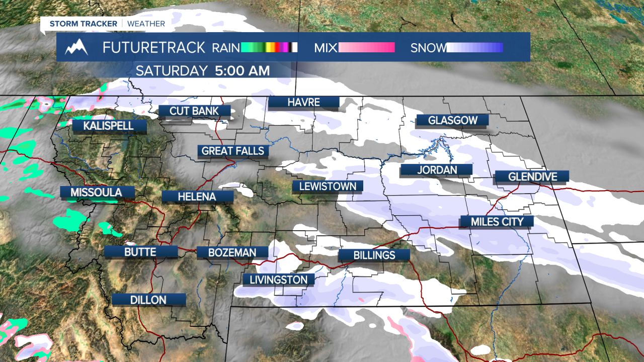
A WINTER STORM WATCH has been issued for the plains north and east of the mountains, including Great Falls, Havre, Lewistown, Billings, and Glasgow through Monday morning
A WINTER WEATHER ADVISORY has been issued for parts north-eastern Montana along the Hi-Line through tomorrow morning
A WINTER WEATHER ADVISORY has been issued for parts north-western Montana, including Kalispell and the Flathead Valley through Sunday morning
——————————————————————————————————————————
Happy Friday! No, this is not click bait! I bet the snow haters wish it was though. Heavy snow is expected Saturday night into Sunday morning for a majority of the state. Winter Storm Warnings and Winter Weather Advisories have been issued accordingly, with likely more on the way throughout the next couple of days.
Some scattered showers popped up in in the mountains and north-central plains early this morning, giving cities like Helena, Great Falls, Townsend, Choteau, and Conrad a light coat of fresh snow.
Our front should pass through Helena this morning, limiting our high to around 40 degrees. Locations north of the front should expect to be cold, cloudy, and snowy. highs will be in the 20s and 30s. The south side of the front, specifically areas in southwest Montana, are still holding on to some warmth. I predict highs to be in the 50s.
We will see snow again late tonight and early tomorrow morning in southwest Montana, as a small disturbance will generate some mixed showers turning to snow. Another light coating is expected for Helena and the surrounding area.
Increased shower coverage and snowfalls rates will begin around the late afternoon tomorrow and continue into Sunday morning. Most of the state will see multiple inches of snowfall, including places like Great Falls, Cut Bank, and Havre that have the possibility to see a foot or more by Sunday night.
At the moment, the Helena Valley should be spared for seeing snowfall amounts measured in feet instead of inches, but the higher elevations around town could approach a foot. I predict around 3-6 inches in the valley.
With all of this snowfall, commutes will be outright dangerous on some of the less maintained highways across the state and even some interstates like I-15 and I-90. I suggest staying home if possible.
Snow showers continue into next week, with temperatures staying below average for a majority of the state. Our next center of low moves in mid-week next week with the possibility of bringing even more snow.
Helena Temperature Records Today:
High: 69° (1993)
Low: -16° (1898)
AVG: 50/27
Great Falls Temperature Records Today:
High: 73° (1928)
Low: -6° (1964)
AVG: 48/24
Again, apologies to the Spring lovers. Please don't blame the weatherman! I'm just the messenger.
Joey Biancone
Meteorologist
Facebook: Meteorologist Joey Biancone
Instagram: joeybianconewx


