


WEDNESDAY, FEBRUARY 25TH: A few rain and snow showers made their way through the Helena area earlier this morning. Up to 4" of snow fell near pass level in the higher elevations of Lewis and Clark and Powell Counties. Due to this, expect driving conditions to be poor on sections of I-15, MacDonald Pass, Flesher Pass, Rogers Pass, and the Lincoln area. Winds have already begun to increase in those areas, adding another hazard to the mix.
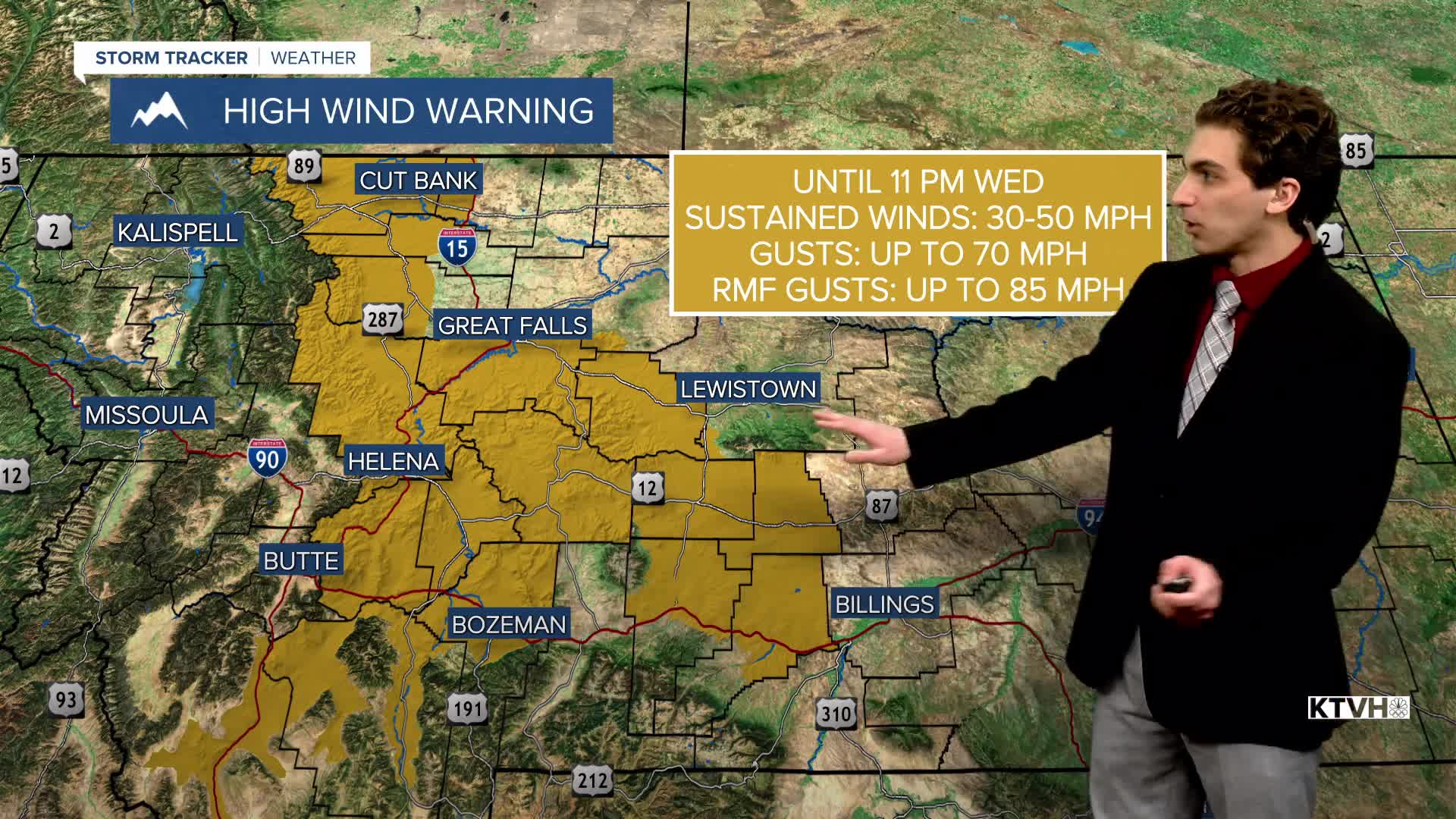
High Wind Warnings are in effect for the Helena area and most of central Montana. Wind gusts could approach 70 MPH by this afternoon for most locations, with isolated gusts exceeding 80 MPH near the Rocky Mountain Front. Dangerous crosswinds are expected to impact driving conditions. Isolated power outages and damage are possible as well. Be sure to bring all loose items indoors.
Highs today will be in the upper 40s to low 50s. As the rain and snow continue to move south out of our area, expect clearing skies.
THURSDAY, FEBRUARY 26TH: Winds are expected to be the strongest on Thursday. Gusts could be approaching 70 MPH for much of north-central Montana and the Helena Valley. The Rocky Mountain Front has the potential to gust around 90 to 100 MPH.
High Wind Warnings are also in effect for Thursday. This is another day where dangerous crosswinds are expected, and Isolated power outages and damage are possible. Although this wind event is not expected to be on the same level as the December 2025 storm, take these warnings seriously.
Highs will reach the low to mid 50s. A chinook arch cloud could develop over the plains.
FRIDAY, FEBRUARY 27TH: Gusty west winds will still be in the forecast through the morning, but a Canadian front from the north will reduce the wind threat by Friday afternoon in the plains. The Continental Divide and Helena will still be windy throughout the day. Highs will reach the 40s and 50s before the arctic air arrives with a bit of lower elevation snow around the Great Falls area and Hi-Line.
SATURDAY, FEBRUARY 28TH: The final day of February will be colder for most with near-to-below-average temperatures except briefly for the plains. The Helena Valley should remain out of the coldest air. Highs will reach the 40s in the capital city.
Light snow is expected from Cut Bank to Miles City. Around 1-3 inches may fall across a wide area in the plains. Snow is not expected to reach Helena at this time.
LONG-RANGE FORECAST: Warmer air returns to begin March. A Total Lunar Eclipse will also be visible in our area in the early morning hours of March 3rd. More to come on that.
——————————————————————————————————————————
WEATHER ALERTS:
NWS WEATHER AND HAZARDS VIEWER
——————————————————————————————————————————
Helena Temperature Records Today:
High: 63 (1983)
Low: -19 (2011)
AVG: 40/19
Great Falls Temperature Records Today:
High: 64 (1896)
Low: -24 (2011)
AVG: 39/16


