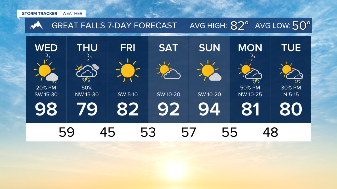
Another very hot day is expected across Montana. Highs will reach the mid-90s to low 100s statewide. Some thunderstorms will form in southwest and central Montana this afternoon, but not a whole lot of rain is expected. The wind will be gusty as well. 30-40 MPH gusts can occur in north-central Montana, with isolated stronger gusts associated with thunderstorms.
A cold front comes through the state tomorrow. It will bring cooler temperatures, as well as more wind. Scattered light showers and a few thunderstorms will form in the afternoon, but again, not a lot of rainfall is expected.
Friday will be slightly cooler than normal with sunny skies. Highs will reach the low 80s.
The weekend will be hot again. Highs in the 90s with mostly sunny to partly cloudy skies. Overall, dry conditions are expected. Another cold front will come through early next week, bringing some wet weather and cooler temperatures.
——————————————————————————————————————————
WEATHER ALERTS:
A HEAT ADVISORY continues for Cascade County below 5000ft, Hill County, Northern Blaine County, and Western and Central Chouteau County until 8 PM Wednesday
A HEAT ADVISORY continues for Central and Southeast Phillips, Central and Southern Valley, Daniels, Sheridan, Western Roosevelt, Petroleum, Garfield, McCone, Richland, Dawson, Prairie, Wibaux, Northern Phillips, Southwest Phillips, Northern Valley, and Eastern Roosevelt until 9 PM Wednesday
A HEAT ADVISORY continues for Powder River, Carter, Southern Rosebud, Southern Big Horn, Southeastern Carbon Counties, and the Bighorn Canyon until 9 PM Wednesday
A HEAT ADVISORY continues for Musselshell, Treasure, Northern Rosebud, Custer, Fallon, Northern Big Horn, Northeastern Yellowstone, and Southwestern Yellowstone until 9 PM Wednesday
A RED FLAG WARNING has been issued for Dawson/McCone/Prairie/Richland/Wibaux Counties; Northern Valley and Northern Phillips Counties; The Little Rockies; The Lower Missouri River Breaks including the Charles M Russell National Wildlife Refuge; Southern Petroleum and Southern Garfield Counties from 4 PM Wednesday until 4 AM Thursday
——————————————————————————————————————————
Helena Temperature Records Today:
High: 101 (1985)
Low: 39 (1889)
AVG: 84/54
Great Falls Temperature Records Today:
High: 99 (2017)
Low: 41 (2020)
AVG: 82/50
Have a great Wednesday!
Joey Biancone
Meteorologist