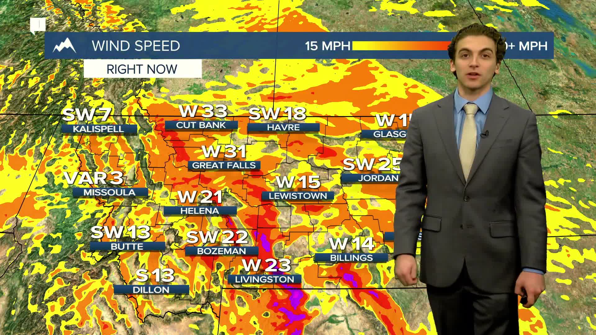


Powerful winds continue to blow through Montana this morning. We will be presented with a variety of weather conditions this week, like more wind, rain, snow, ice, and more.
We recorded a 101 MPH wind gust south of Glacier National Park on Monday night! The winds will slowly wind down through the rest of today, becoming calmer overnight. They will pick back up again tomorrow morning, where gusts along the Rocky Mountain Front can exceed 60 MPH again. The wind will be lighter heading into the rest of the week.
Rain and snow will mix in at times in Helena throughout the next couple of days, but with the wind, I don't anticipate seeing any significant rain and snow totals.
There will be arctic air pushing into the state Wednesday night into Thursday. This will allow lower elevations wit start receiving snow. Areas like Great Falls, Lewistown, and Harve may pick up a few inches by the end of this week. Thursday and Friday are looking like the best days to pick up some snow. Helena is right on the line of rain and snow.
Drier conditons will be present to begin nect week.
——————————————————————————————————————————
WEATHER ALERTS:
A HIGH WIND WARNING continues for the Continental Divide along the Rocky Mountain Front, Eastern Toole and Liberty Counties, Eastern Pondera and Eastern Teton Counties, Cascade County below 5000ft, Upper Blackfoot and MacDonald Pass, and Gates of the Mountains until 10 AM Tuesday
A HIGH WIND WARNING continues for the foothills and plains adjacent to the Rocky Mountain Front, and Eastern Glacier, Western Toole, and Central Pondera Counties until 10 AM Tuesday
A HIGH WIND WARNING continues for the Madison River Valley until 10 AM Tuesday
A HIGH WIND WARNING continues for the Beartooth Foothills and Livingston Area until 11 AM Tuesday
A HIGH WIND WARNING continues for the Absaroka/Beartooth Mountains and Crazy Mountains until 11 AM Tuesday
A HIGH WIND WARNING continues for the Bears Paw, Highwood, Little Belt, and Snowy Mountains, Hill County, Northern Blaine County, Western and Central Chouteau County, Judith Basin County and Judith Gap, Fergus County below 4500ft, Big Belt, Bridger and Castle Mountains, and Meagher County Valleys until 3 PM Tuesday
A HIGH WIND WARNING continues for all of northeast Montana until 5 PM Tuesday
A HIGH WIND WARNING continues for Judith Gap, Southern Wheatland, Melville Foothills, and Northern Sweet Grass until 5 PM Tuesday
A HIGH WIND WARNING continues for the Golden Valley and Northern Stillwater until 5 PM Tuesday
A HIGH WIND WARNING continues for Portions of central, south central, and southeast Montana until 5 PM Tuesday
A HIGH WIND WARNING continues for Red Lodge Foothills and Southeastern Carbon until 5 PM Tuesday
A WINTER STORM WARNING continues for the Absaroka/Beartooth Mountains until 5 PM Wednesday
An AVALANCHE WARNING continues for the Absaroka/Beartooth Mountains until 5 AM Wednesday
An AVALANCHE WARNING continues for the Whitefish, Swan, and Flathead Ranges, as well as the Apgar Mountains, Lake McDonald Valley, and Marias Pass areas of Glacier National Park until 5 AM Wednesday
A WINTER WEATHER ADVISORY continues for all of northeast Montana until 2 PM Tuesday
A WINTER WEATHER ADVISORY continues for the Continental Divide along the Rocky Mountain Front until 11 AM Wednesday
A WINTER WEATHER ADVISORY continues for Marias Pass, Highway 83 Bigfork to Swan Lake, Highway 83 Seeley Lake to Condon, Glacier National Park, Highway 200 Bonner to Greenough, Polebridge, Essex, I-90 East Missoula to Bearmouth, and Bad Rock Canyon until 11 AM Wednesday
A WIND ADVISORY continues for the West Glacier Region until 11 AM Tuesday
A HIGH WIND WATCH has been issued for the foothills and plains adjacent to the Rocky Mountain Front, and Eastern Glacier, Western Toole, and Central Pondera Counties from Wednesday morning until Wednesday afternoon
A FLOOD WATCH continues for Flathead, Lake, Lincoln, and Sanders Counties until Thursday afternoon
——————————————————————————————————————————
Helena Temperature Records Today:
High: 59 (1957)
Low: -30 (1972)
AVG: 34/16
Great Falls Temperature Records Today:
High: 62 (1979)
Low: -38 (1919)
AVG: 36/17


