


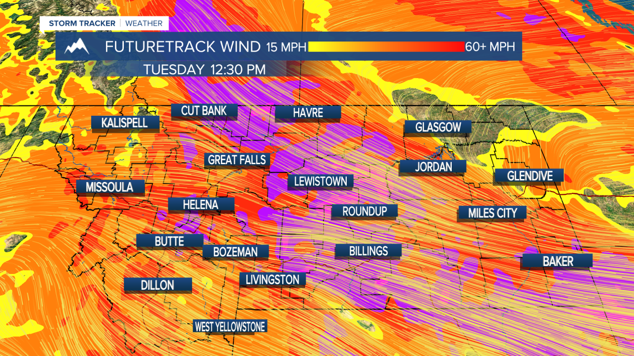
A HIGH WIND WARNING continues for much of the state east of the Continental Divide through tonight.
A BLIZZARD WARNING has been issued for the Little Belt and Highwood Mountains from 12 PM today through 12 AM Thursday.
A WINTER STORM WARNING has been issued for East Glacier and the Rocky Mountain Front from 12 PM today through 12 AM Thursday.
A WINTER STORM WARNING has been issued for the Big Belt, Judith, Bridger, Castle, and Snowy ranges from 12 PM today through 12 AM Thursday.
A WINTER STORM WARNING has been issued for the Madison, Gallatin, and Centennial ranges from 6 PM tonight through 12 AM Thursday.
A WINTER WEATHER ADVISORY has been issued for Cascade county below 5000 feet, Judith Basin County and Judith Gap-Fergus County below 4500 feet from 6 PM tonight through 12 PM tomorrow.
A WINTER WEATHER ADVISORY has been issued for Butte, MacDonald Pass, Highway 12 Garrison to Elliston, Homestake Pass, and Georgetown Lake from 9 PM tonight through 11 AM tomorrow.
A WINTER WEATHER ADVISORY has been issued for the Bears Paw Mountains and Sweetgrass Hills from 6 PM tonight through 6 AM tomorrow.
A WINTER WEATHER ADVISORY has been issued for Marias Pass from 6 PM tonight through 11 AM tomorrow.
A WINTER STORM WATCH has been issued for the Absaroka, Beartooth, Crazy, Pryor, and northern Bighorn Mountains from late tonight through Thursday morning.
A LAKE WIND ADVISORY has been issued for the Flathead and Mission Valley's from 9 AM this morning through 8 PM Thursday.
A WIND ADVISORY continues for the Butte/Blackfoot Region through 9 PM tonight.

Mustard - High Wind Warning
Purple - Winter Weather Advisory
Blue - Winter Storm Watch
Pink - Winter Storm Warning
Tan - Wind/Lake Wind Advisory
——————————————————————————————————————————
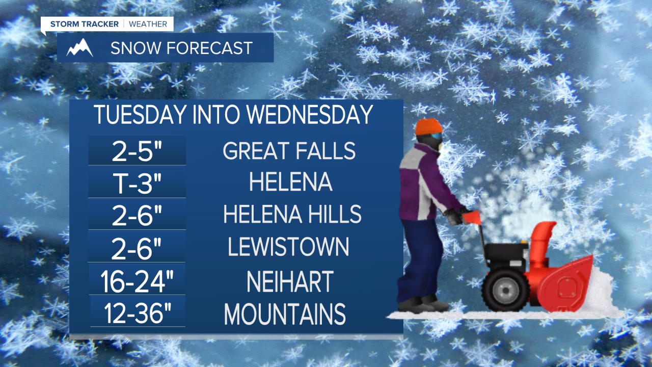
Blizzard Warnings have been issued for the Little Belt and Highwood Mountains for whiteout conditions and feet of snow to come. Much of the state will see high wind and snow lasting through tomorrow.
Heavy rain and snow is expected today across much of the state. We have already seen rain rates this morning of well over an inch an hour near Glasgow and Jordan.
The surface low that has been causing our early-week storminess is actually going to backtrack towards the west throughout the day. This will cause the heavy rain that is currently affecting the eastern and central portions of the state to also migrate westward. Great Falls could see rain around noon today. Helena will see that rain move in later this afternoon and tonight.
Travel should be avoided in Blizzard Warned areas, and precautions should be taken in other Winter Alerted areas as driving could be dangerous.
Wind alerts are still active through tonight as a strong pressure gradient still exists between the continental divide and the center of low. Gusts over 60 MPH are likely once again for much of the state.
Heavy snow is expected for much of the mountain ranges. Feet of snow are possible in the Little Belt's, Highwood's, and Glacier National Park. Localized amounts greater than 1 foot are possible in most other ranges. Valleys and plains will see snow overnight tonight as the rain/snow line falls to around 4000-4500 feet.
Rain and snow will continue through most of the day tomorrow, becoming more "showery" in nature by the afternoon and evening hours. Temperatures will be cold for a lot of the state. We will be in the 40s.
Once this system finally starts to move out on Thursday, we will enter a drier and warmer pattern with much less wind. Some showers will stick around early on in the day, but most of us will stay dry. Temperatures warm back close to 60°.
Mostly sunny to clear skies for much of the state through the weekend. Temperatures will be in the 70s.
Helena Temperature Records Today:
High: 86° (1992)
Low: 23° (1885)
AVG: 64/39
Great Falls Temperature Records Today:
High: 86° (1987)
Low: 24° (1892)
AVG: 62/35
Remember to be careful commuting today and tomorrow!
Joey Biancone
Meteorologist
Facebook: Meteorologist Joey Biancone
Instagram: joeybianconewx
Email: joey.biancone@ktvh.com
