


The Aurora Borealis put on a show in the cold last night! It will be getting even colder, though. By Friday, we will likely be looking at sub-zero temperatures for many.
WEDNESDAY, JANUARY 21ST: Wind continues to be gusty in eastern Montana this morning as a small disturbance passes through the area. The wind will begin to lose intensity by this afternoon. High temperatures across the state will only reach the 20s and 30s today, with northeastern Montana particularly cold, with wind chills near zero.
A light snow shower or two is possible near the southern Rocky Mountain Front and the Little Belt Mountains in the morning; otherwise, dry conditions prevail today. More clouds than sun will be present.
There is a slight chance the northern lights may be out again tonight, but we will be dealing with cloud cover again.
THURSDAY, JANUARY 22ND: A cold front is expected to move through the state Thursday afternoon through Thursday evening. It will only get as warm as the 20s before temperatures drop significantly heading into Friday morning.
Snow flurries are possible once the front reaches the mountains, bringing a north wind to upslope on the Rocky Mountain Front, Big Belts, and Little Belts. Accumulation will be less than one inch for areas in the north-central plains.
FRIDAY, JANUARY 23RD: The coldest air of the season so far will be here in the morning. Lows dropping below zero in the morning for many across the state. Wind chills could dip down to -40° in northeast Montana. Wind chills in the Helena and Great Falls areas will be in the -0s, -10s, and potentially the -20s at times. High's will only reach the single digits for most. Make sure you bundle up well if you're going to be outdoors.
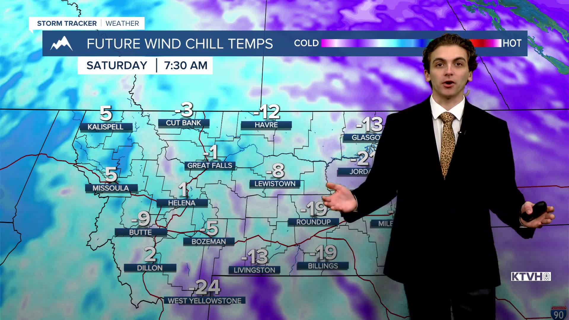
SATURDAY, JANUARY 24TH: It is becoming increasingly likely that some light snow will fall in the plains adjacent to the Rocky Mountain Front on Saturday. There may be some locally heavier amounts of several inches in areas near the central island mountain ranges and the Little Belt Mountains.
Temperatures will be at or near zero yet again in the morning, only warming into the teens and 20s by the afternoon.
——————————————————————————————————————————
WEATHER ALERTS:
A HIGH WIND WARNING continues for Fergus County below 4500ft and Northern Blaine County until 8 AM Wednesday
A HIGH WIND WARNING continues for Eastern Toole and Liberty Counties, and Bears Paw Mountains and Southern Blaine until 8 AM Wednesday
A HIGH WIND WARNING continues for Carter, Custer, Fallon, and Powder River Counties until 9 AM Wednesday
A HIGH WIND WARNING continues for Southwest Phillips County until 9 AM Wednesday
A HIGH WIND WARNING continues for Central and Southern Valley, Northern Phillips, Northern Valley, and Western Roosevelt Counties until 9 AM Wednesday
A HIGH WIND WARNING continues for Central and Southeast Phillips, Garfield, and McCone Counties until 9 AM Wednesday
A HIGH WIND WARNING continues for Dawson, Prairie, and Wibaux Counties until 9 AM Wednesday
A EXTREME COLD WATCH has been issued for Daniels, Eastern Roosevelt, Richland, and Sheridan Counties from Wednesday evening until Saturday morning
A EXTREME COLD WATCH has been issued for Central and Southern Valley, Northern Phillips, Northern Valley, and Western Roosevelt Counties from Wednesday evening until Saturday morning
——————————————————————————————————————————
Helena Temperature Records Today:
High: 52 (1950)
Low: -32 (1962)
AVG: 33/14
Great Falls Temperature Records Today:
High: 57 (2009)
Low: -32 (1943)
AVG: 36/15


