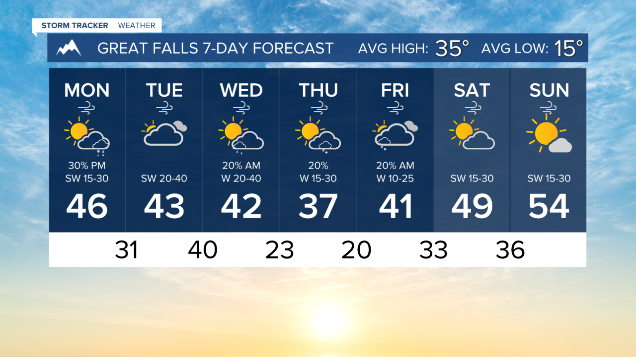


Some unsettled weather will be moving through our area over the next few days. Expect the week to be cooler and winder with some rain and snow.
The wind will be picking up today across the plains. Expect gusty winds to continue through most of this week. The wind will begin to decrease in Helena towards the end of the week. I expect gusts to reach around 30-40 MPH in the Helena area on Tuesday and Wednesday.
High temperatures are expected to fall into the 30s for most of the week, as an upper-level trough moves into the state. A couple of cold fronts, one on Monday night and one on Wednesday morning, will bring scattered snow showers during those periods.
An upper-level ridge builds over the weekend, bringing warmer air to the plains and allowing valley inversions to set in.
——————————————————————————————————————————
WEATHER ALERTS:
A HIGH WIND WARNING has been issued for the Rocky Mountain Front and adjacent foothills and plains, and Eastern Glacier, Western Toole, and Central Pondera Counties from 11 PM Monday until 11 PM Tuesday
A HIGH WIND WARNING has been issued for the Rocky Mountain Front and adjacent foothills and plains, and Eastern Glacier, Western Toole, and Central Pondera Counties from 8 AM Tuesday until 11 PM Tuesday
A WIND ADVISORY has been issued for Beartooth Foothills and Livingston Area from 2 AM Tuesday until noon Wednesday
A HIGH WIND WATCH has been issued for Judith Gap, Southern Wheatland, Melville Foothills, and Northern Sweet Grass from Tuesday morning until Tuesday evening
A HIGH WIND WATCH has been issued for the Highwood, Little Belt, Judith, and Snowy Mountains, Eastern Toole and Liberty Counties, Eastern Pondera and Eastern Teton Counties, Western and Central Chouteau County, and Fergus County below 4500ft from Tuesday morning until Tuesday evening
A WINTER STORM WATCH has been issued for Highway 56 Bull Lake Road, Highway 37 Eureka to Libby, and Highway 2 Kalispell to Libby from Tuesday afternoon until Wednesday morning
A WINTER STORM WATCH has been issued for Highway 200 Thompson Falls to Plains, Highway 200 Trout Creek to Heron, Evaro Hill, and I-90 Lookout Pass to Haugan from Tuesday afternoon until Wednesday morning
——————————————————————————————————————————
Helena Temperature Records Today:
High: 54 (1903)
Low: -37 (1942)
AVG: 31/12
Great Falls Temperature Records Today:
High: 61 (1914)
Low: -30 (1982)
AVG: 35/15