


A WINTER WEATHER ADVISORY continues for the mountains of southwest Montana, including MacDonald Pass, through 9 PM tonight.
A WINTER STORM WATCH has been issued for the Little Belt and Highwood Mountains from Wednesday morning through Thursday morning.
A WINTER STORM WATCH has been issued for East Glacier and the northern Rocky Mountain Front from tomorrow evening through Thursday morning.
A FIRE WEATHER WATCH has been issued for northeast Montana from from tomorrow morning through tomorrow evening.
——————————————————————————————————————————
Our temperatures will be much below average for the rest of the week allowing for some late April/early May snow accumulation in higher elevations. Strong wind will also blow today into Wednesday.
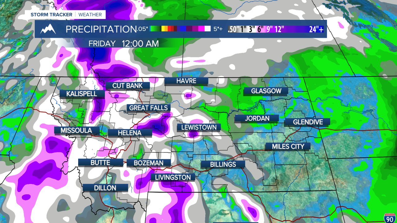
We continue with an unsettled, cooler pattern today with a cold front advancing through the state bringing showers and thunderstorms throughout the day, as well as some mountain snow. 2-8 inches are expected in the higher terrain of southwest Montana through tonight. High temperatures will be in the low to mid 50s today. with some strong wind gusts in much of western Montana.
Tomorrow is the highest potential for strong wind along the Rocky Mountain Front. Gusts over 50 MPH are possible along the intimidate front. Gusts over 35 mph are likely in the rest of the state.

Along with the wind will come colder temperatures as well. We will be in the 40s for highs across much of the western half of the state. Out east, temperatures will be relatively warmer in the 50s. Scattered snow showers will be present in the higher terrain.
Wednesday is our best shot to see some brief accumulation snow at elevations around 3500-4000 feet. More heavy and consistent precipitation seems likely during the daytime hours. We could see a dusting to an inch in Helena. Most snowfall will be concentrated in the Eastern half of Glacier National Park, as well as the Highwood's and Little Belt's. Over a foot is possible in these locations.
Temperatures will still be in the low to upper 40s for most of the state. This about 10-15 degrees colder than the average high for this time of year.
We will stay unsettled into the weekend, when models diverge heavily. The American model allows riding to return to the area and much warmer temperatures and no rain. On the other hand, the European model is showing the total opposite. Waiting for these models to come into agreement before talking specifics.
Also, a tornado outbreak occurred in the central plains this weekend. Five people lost their lives, including an infant. This was the worst outbreak of 2024 so far. We are entering the heart of severe weather season in the United States. Although out severe weather season in Montana doesn't reach its peak until June and July, keep this as a reminder to always stay weather aware and prepared.
Helena Temperature Records Today:
High: 86° (1992)
Low: 14° (1954)
AVG: 61/36
Great Falls Temperature Records Today:
High: 87° (1939)
Low: 13° (2019)
AVG: 59/33
Prepare for the cold!
Joey Biancone
Meteorologist
Facebook: Meteorologist Joey Biancone
Instagram: joeybianconewx
Email: joey.biancone@ktvh.com
