


MONDAY, APRIL 6TH: Today will be another beautiful day with highs in the 50s and 60s under partly to mostly cloudy skies. Wind will be on the lighter side in Helena and Great Falls, but a little gustier out towards the Havre and Lewistown areas.
Most of the state will be dry, aside from flurries moving through northeast Montana this morning, as a few pop-up afternoon showers near Lewistown and the Beartooth Mountains.
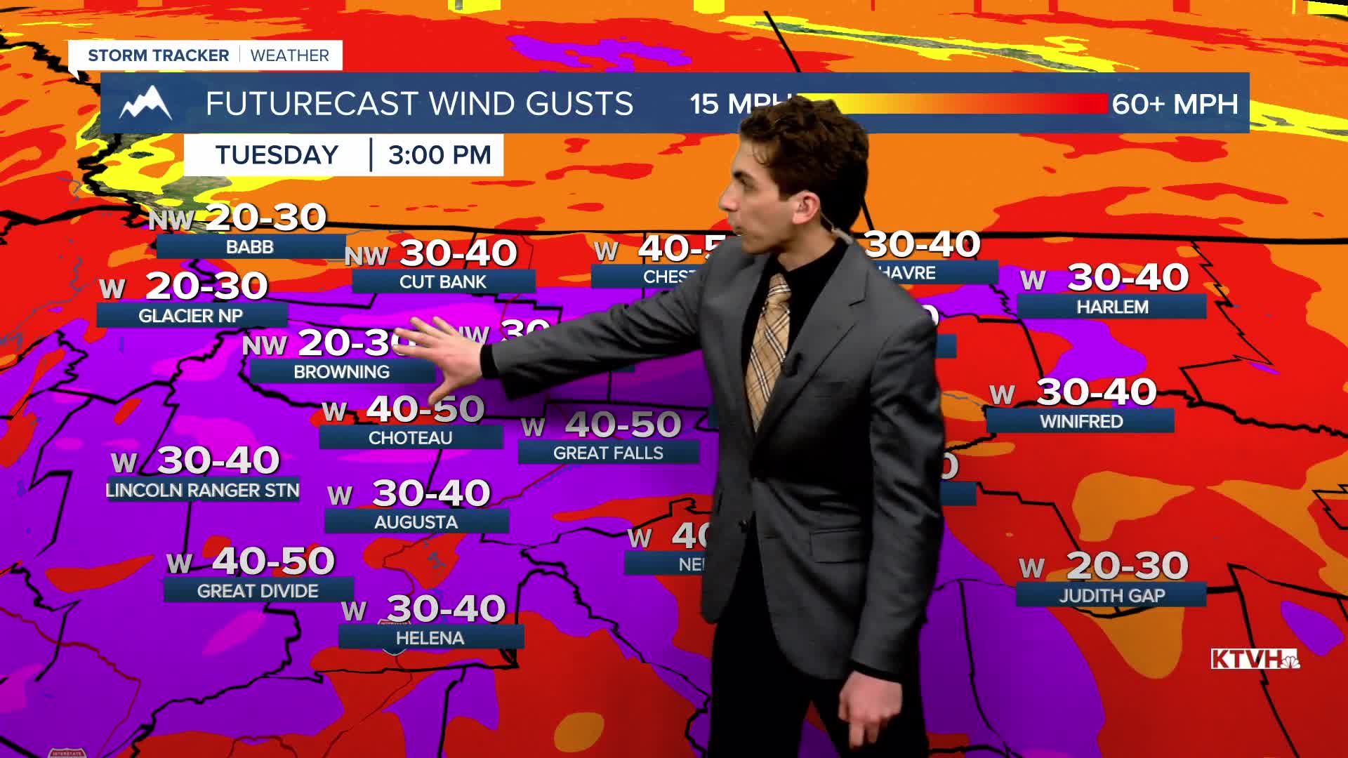
TUESDAY, APRIL 7TH: A strong wind event is set to unfold on Tuesday, especially in the afternoon hours across much of central and southwest Montana. A low-pressure system with an associated cold front will move into the area. This, combined with strong mid-level winds, will enhance surface-level winds. Gusts could reach up to 75 MPH in lower elevations, with the Rocky Mountain Front gusting to near 90 MPH at times.
Expect partly cloudy skies for most of the day, with the wind pushing high temperatures into the mid to upper 60s.
Most of the day will be dry, but a few rain showers will form along the cold front as it moves from northwest to southeast in the afternoon and evening.
WEDNESDAY, APRIL 8TH: Winds will die down in the morning throughout central Montana, but will still be gusty throughout the afternoon in the eastern portion of the state. Temperatures will be cooler behind the front, with morning lows in the 20s and 30s. Afternoon highs will only reach the 40s and 50s.
A few morning rain and snow showers will impact northern Montana on the backside of the low-pressure system. Accumulating snow is not likely at this time.
THURSDAY, APRIL 9TH: A shortwave disturbance bringing isolated rain and snow showers will move through north-central Montana on Thursday. This may bring a light coating of snow in the mid to late morning, but it will quickly melt off by the afternoon. Morning lows will be in the 20s and 30s again. Highs will reach the 50s.
LONG-RANGE FORECAST: Another storm system begins to influence the state on Saturday afternoon. Moist southwest flow ahead of a center of low will bring air temperatures in the 60s and 70s with scattered thunderstorms. There will be some wet weatehr around on Sunday as well with cooler temperatures.
——————————————————————————————————————————
WEATHER ALERTS:


——————————————————————————————————————————
Helena Temperature Records Today:
High: 75 (1988)
Low: 5 (1975)
AVG: 54/30
Great Falls Temperature Records Today:
High: 74 (1976)
Low: -6 (1975)
AVG: 52/28


