


EARTH DAY: Rain showers and thunderstorms will develop in western Montana from the late morning to early afternoon. A few thunderstorms could produce heavy rain and gusty winds. Once the initial round of showers and thunderstorms passes, expect the conversion to a more widespread rain, and then eventually to all snow by early Thursday morning.
Unlike last week's storm, there is a higher confidence in seeing more widespread precipitation with the way this system is developing.
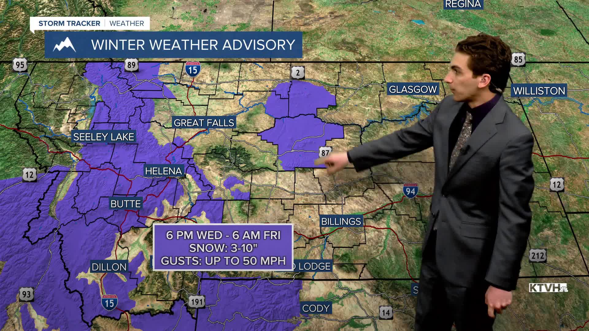
Blizzard-like conditions are possible over the mountain ranges of central Montana, especially the Little Belt Mountains, late tonight and tomorrow morning, with heavy snowfall rates and wind gusts in the mountains reaching up to 60 MPH.
High temperatures will range from the 50s in the western portions of the state to the 80s in the eastern plains. Expect partly cloudy skies in the morning, then mostly cloudy for the rest of the day.
Stronger winds develop for a lot of the state by the afternoon, with maximum gusts approaching 40 MPH.
THURSDAY, APRIL 23RD: Widespread light snow is expected to fall through at least Thursday morning with the current track of the storm system. Accumulation will be light in most lower elevations. Areas like Lewistown and Bozeman could see isolated, heavier amounts. The most impactful snow will be over the mountains of central Montana.
High temperatures will only reach the 30s and 40s, a significant cool-down compared to earlier in the week.
Scattered snow showers should stick around Thursday afternoon.
FRIDAY, APRIL 24TH: Scattered snow showers will stick around on Friday. Expect temperatures to be in the 30s for most of the day. Winds will be out of the north at 10-25 MPH.
SATURDAY, APRIL 25TH: Morning temperatures will be cold in the teens and 20s. Afternoon temperatures will warm into the upper 30s to low 40s. Isolated snow showers will develop over the mountains. Expect partly cloudy skies with light winds out of the north from 5 to 15 MPH.
LONG-RANGE FORECAST: Colder and generally unsettled conditions will stick around through the weekend.
——————————————————————————————————————————
WEATHER ALERTS:


——————————————————————————————————————————
Helena Temperature Records Today:
High: 83 (1906)
Low: 17 (1968)
AVG: 59/34
Great Falls Temperature Records Today:
High: 83 (1969)
Low: 8 (1967)
AVG: 57/31


