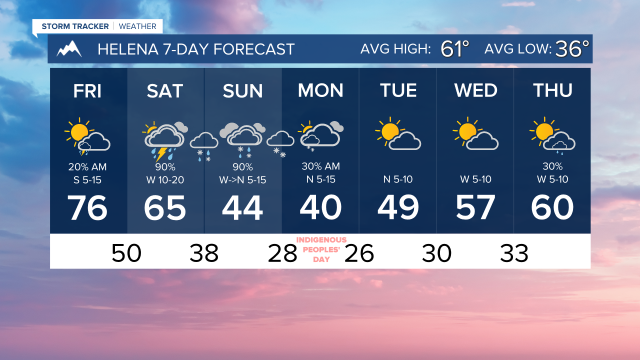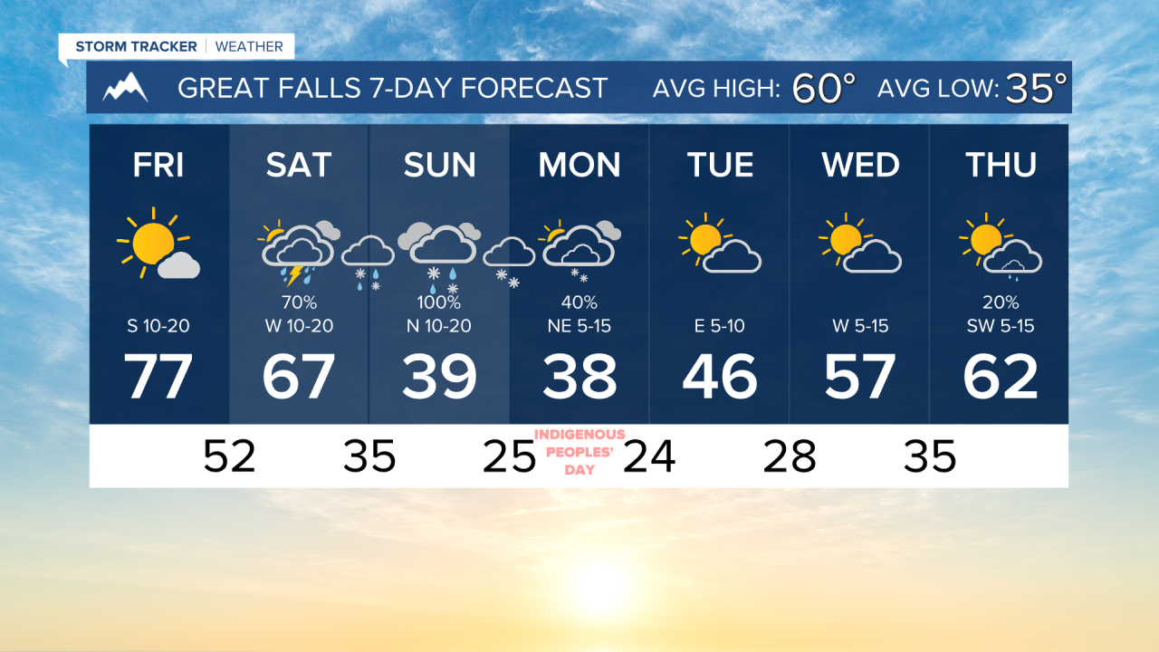


Temperatures fall off a cliff this weekend with an impending storm system bringing thunderstorms, rain, and eventually snow. Snow could reach lower elevations by Sunday evening.
Today will be a really nice day, aside from a few isolated morning thunderstorms moving through southwest Montana. Highs reach the mid-70s for most today under mostly sunny to partly cloudy skies.
It will be breezy for most of the state today and over the weekend with the storm system passing through. Expect wind around 10-20 MPH wth gusts exceeding 30 MPH at times.
A Pacific cold front comes through the area tomorrow morning, bringing a round of thunderstorms. Highs drop about 10-15 degrees across western Montana. A stronger line of heavy rain and thunderstorms redevelops in central and eastern Montana tomorrow afternoon and evening. Precipitation slowly starts to build back into western Montana by the nighttime hours, with snow levels starting to drop. Most of the snow that falls Saturday into Sunday morning will be limited to the mountains.
It will be a soggy and cold Sunday. Highs only reach the 30s and 40s. Snow levels will continue to slowly decrease during the day as a Canadian cold front comes through the state. Snow levels could reach valley floors and the north central plains by Sunday evening.
There will be some snow showers left on Monday with uploping occurring at the bases of the mountains, particularly along the Rocky Mountain Front and Big Belt's. Highs will once again be in the 30s and 40s.
A slow warming pattern takes hold during the middle of next week, with partly cloudy skies.
——————————————————————————————————————————
WEATHER ALERTS:
A LAKE WIND ADVISORY has been issued for Fort Peck Lake from 11 AM Friday to 9 PM Friday
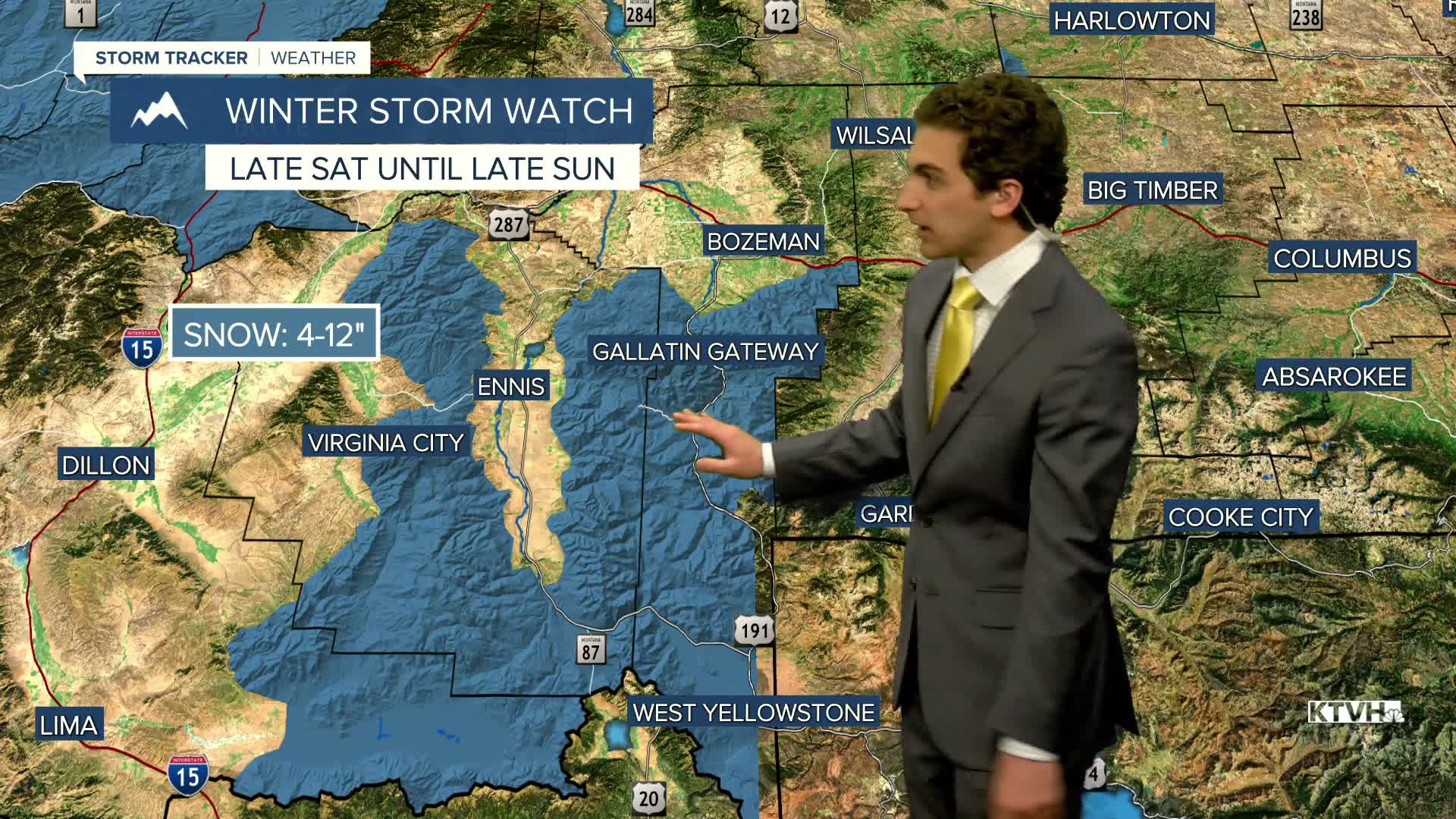
A WINTER STORM WATCH has been issued for the Little Belt and Highwood Mountains and Gallatin and Madison County Mountains, and Centennial Mountains from Saturday evening until late Sunday night
A WINTER STORM WATCH has been issued for the Crazy Mountains from Saturday evening until late Sunday night
A WINTER STORM WATCH has been issued for the Continental Divide along the Rocky Mountain Front from Saturday evening until late Monday morning
A WINTER STORM WATCH has been issued for Polebridge, Bad Rock Canyon, Essex, Highway 83 Bigfork to Swan Lake, Glacier National Park higher elevations, including Going-to-the-Sun Road and Logan Pass, and Marias Pass from Saturday evening until late Monday morning
A WINTER STORM WATCH has been issued for Highway 93 Sula to Lost Trail Pass from Saturday evening until late Monday morning
A WINTER STORM WATCH has been issued for Highway 37 Eureka to Libby, Highway 2 Kalispell to Libby, Highway 56 Bull Lake Road, and Highway 93 Eureka to Whitefish from Saturday evening until late Monday morning
A WINTER STORM WATCH has been issued for Highway 83 Seeley Lake to Condon from Saturday evening until late Monday morning
A WINTER STORM WATCH has been issued for MacDonald Pass, Homestake Pass, Butte, and Georgetown Lake from Saturday evening until late Monday morning
A WINTER STORM WATCH has been issued for Lower Clark Fork Region including Lookout Pass on I-90 from Saturday evening until late Monday morning
——————————————————————————————————————————
Helena Temperature Records Today:
High: 87 (2015)
Low: 9 (2009)
AVG: 61/36
Great Falls Temperature Records Today:
High: 86 (1934)
Low: 0 (2019)
AVG: 60/35