


A WINTER WEATHER ADVISORY has been issued for the higher terrain south and west of Helena, including MacDonald Pass and Butte, through 9 AM this morning
——————————————————————————————————————————
What a weekend for weather and space enthusiasts. Most of Montana received several inches of snow on Saturday and Sunday with an early spring storm. There was a lot of cool things going on beyond our troposphere too. That included the full Worm Moon, a Penumbral Lunar Eclipse, and a geomagnetic storm generating Aurora's across much of the northern hemisphere.
Unfortunately, we can't have both at the same time. The snow and clouds won the battle this time, and blocked out a lot of the night sky Sunday across much of Montana.
The full Worm Moon is the first full moon of spring season and gets its name by the Native American tribes noting that beetle larvae emerging from thawing tree bark in the transition from winter to spring.
What made this specific full Worm Moon special was the Penumbral Eclipse that accompanied it. It just so happened that they both occurred last night. Penumbral Eclipses are a type of Lunar Eclipse that occurs when the moon passes through the Earth's outer shadow or "Penumbra", making the moon appear to have a faint shading on the moon's face. The next shot at seeing one won't be until February 20-21 of 2027.
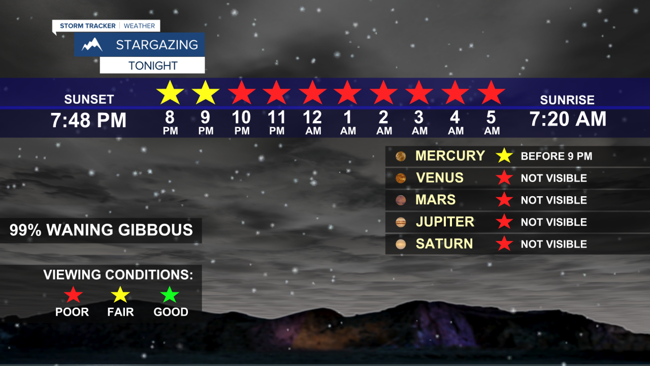
There was also a geomagnetic storm caused by a coronal mass ejection from the sun that hit Earth over the weekend and will continue into tonight. the G4 or "severe" category was reached yesterday afternoon, causing Aurora Borealis, or better known as Northern Lights, across much of the northern hemisphere. If it weren't for the clouds, we would have been treated to quite the spectacle. Unfortunately for space enthusiasts, the cloud cover will not let up tonight. The storm was downgraded to G2 (moderate) status for today and tonight.
Now that we geeked out a little, we can get to the forecast for the rest of the week.
Today we will see clearing skies throughout most of the state with only a few isolated snow showers in higher elevations. Clouds and snow will start to build back in late this afternoon and overnight. Highs will be in the low 40s for southwest Montana. The central portions and along the Hi-Line will be in the 20s and 30s.
Tomorrow, we will see consistent snow showers early, turning into rain around mid-day for southwest Montana, or specifically areas south of the stationary boundary. Helena's high will be in the mid 40s. Cold air persists for areas north of the boundary with temperatures similar to today.
After some drying and warming on Wednesday. another system makes its way into Montana, delivering more snow and rain to much of the state on Thursday and Friday.
Helena Temperature Records Today:
High: 74° (1999)
Low: -30° (1955)
AVG: 51/27
Great Falls Temperature Records Today:
High: 73° (1999)
Low: -17° (1955)
AVG: 49/25
Enjoy your Monday and stay curious!
Joey Biancone
Meteorologist
Facebook: Meteorologist Joey Biancone
Instagram: joeybianconewx
