


A HIGH WIND WARNING has been issued for Judith Gap, Southern Wheatland, Melville Foothills, and Northern Sweet Grass from 12 PM this afternoon through midnight tonight.
A WIND ADVISORY has been issued for the Missoula and Bitterroot Valley's from 12 PM this afternoon through 8 PM tonight.
A WIND ADVISORY has been issued for the Butte and Blackfoot region from 12 PM this afternoon through 8 PM tonight.
A WIND ADVISORY has been issued for the Beartooth foothills from 12 PM this afternoon through midnight tonight.
A LAKE WIND ADVISORY has been issued for Fort Peck Lake from 8 AM this morning through 9 PM Saturday.
——————————————————————————————————————————
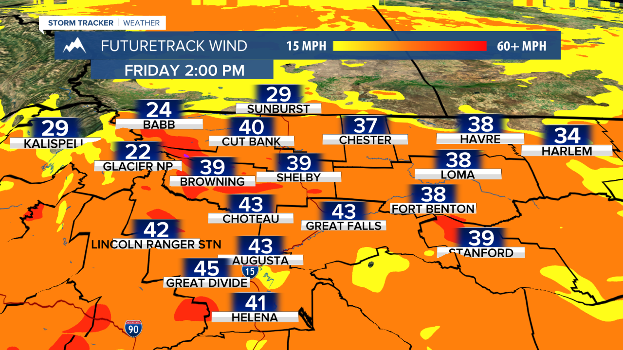
Several wind alerts have been issued ahead of another day of strong wind in western Montana. A severe threat for isolated storms with gusty winds and hail is in place for the southeast this afternoon.
A Pacific cold front is currently marching its way through the western tier of the state, bringing light showers and increasing wind. Some light snow is falling on the Rocky Mountain Front. Wind gusts could exceed 50 MPH through most of the west.
We had some warm morning lows, with temperatures in the low to mid 50s, but we won't warm that much today. Highs will be around 60°.
After the cold front, some diurnal showers will develop this afternoon in the higher terrain. A few showers may bring some snow to the mountains around Helena. Snowfall will be light. It is possible for some icy road conditions tomorrow morning.
There is a threat for severe thunderstorms along the eastern border of the state today. The same cold front that is bring showers to the west will reach places like Miles City and Gelndive later this afternoon, which are both in a level 1/5 risk area. Some portions of extreme southeast Montana are in a level 2/5 risk, along the border of the South Dakota. Damaging wind and small hail will be the primary risks.

Tomorrow will be a drier, warmer, and less active day. Temperatures will warm to near seasonal average. This warm-up will be brief however, with several small disturbances on the way.
On Sunday a small trough makes its way into the state giving way to rain and snow showers for much of the higher terrain. Highs will take a dip into the 50s for much of us. Snow will be possible around 5000 feet Sunday night, but again not a lot of snowfall is expected.
To begin next work week, isolated showers and storms are possible on Monday and Tuesday.
A larger-scale system will affect the state of Wednesday and Thursday of next week. Heavy rainfall seems likely, along with the possibility of some accumulating snow for the mountains. Still way too early to talk specifics.
Helena Temperature Records Today:
High: 90° (2006)
Low: 26° (1943)
AVG: 67/42
Great Falls Temperature Records Today:
High: 87° (2006)
Low: 26° (2003)
AVG: 65/39
Have a great weekend!
Joey Biancone
Meteorologist
Facebook: Meteorologist Joey Biancone
Instagram: joeybianconewx
Email: joey.biancone@ktvh.com
