


A WINTER WEATHER ADVISORY has been issued for portions of central and north central Montana, including Glacier NP, the Rocky Mountain Front, the Big and Little Belts, and the Highwoods from 9 PM tonight through noon tomorrow.
A WINTER WEATHER ADVISORY has been issued for the lower elevations of south-central Montana from 9 PM tonight through 6 AM Thursday.
A WINTER STORM WARNING has been issued for the Gallatin and Madison Ranges from 6 PM this afternoon through 6 PM tomorrow.
A WINTER STORM WARNING has been issued for the Absaroka, Beartooth, Pryor, and Bighorn Ranges from 6 PM this afternoon through 6 PM Thursday.
A LAKE WIND ADVISORY has been issued for Fort Peck Lake through 9 PM Thursday.
A RED FLAG WARNING has been issued for areas around Fort Peck Lake from 9 AM today through 9 PM today.
——————————————————————————————————————————
Temperatures will return to much below average after a cold front advances through the state this afternoon. Snow is in the forecast, with the most activity possible tonight into early tomorrow morning.
Winter weather alerts have been issued for a majority of the higher terrain in western and south-central portions of the state. In addition to the wintry alerts, there is a fire weather concern for northeastern Montana. Strong gusty winds exceeding 30 mph combined with low relative humidity are prime ingredients to ignite wildfires. A Red Flag Warning has been issued for areas around Fort Peck Lake, inducing Glasgow and Glendive.

Temperatures will be about seasonally average today around the capital. Mid-50s is to be expected ahead of the arrival of the cold front. Out east will be much warmer, into the 60s.
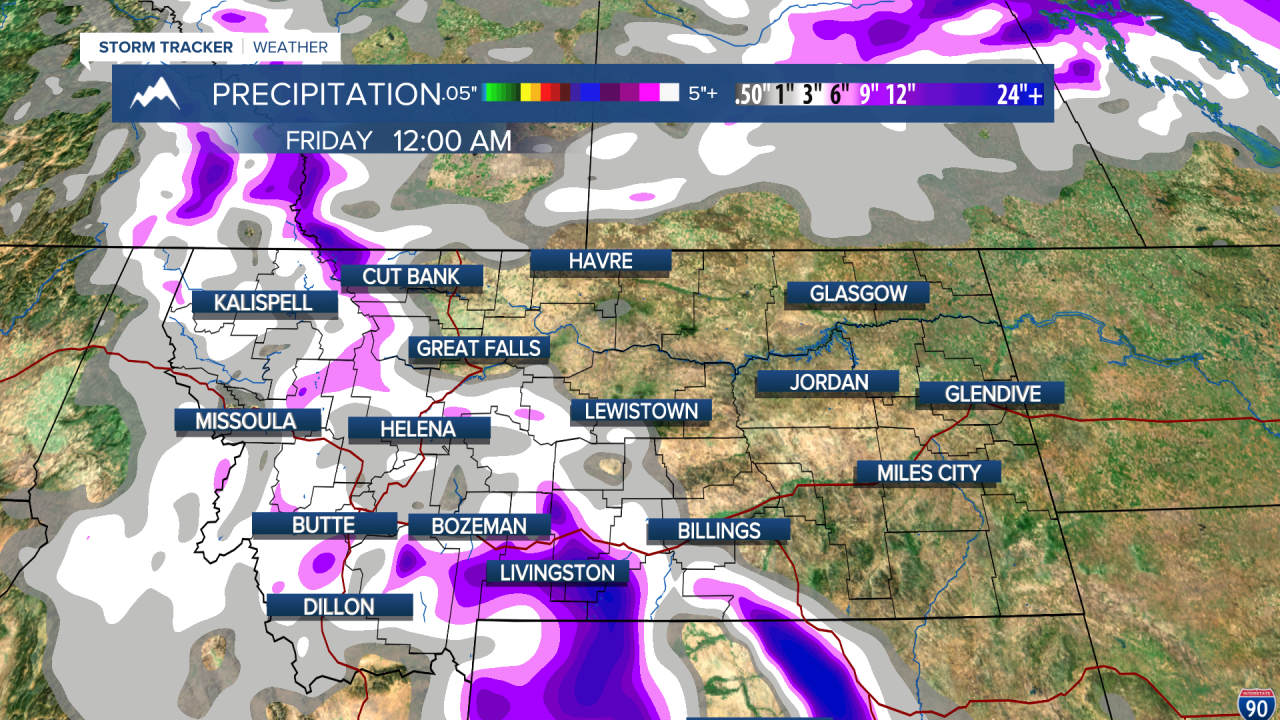
Pockets of heavy snowfall possible in the Absaroka, Beartooth, and the Lewis and Clark Ranges as early as this afternoon. A rain/snow mix is possible for much of the valleys into this evening, when we will see a switch to fully snow into Wednesday morning.
Much of western and central portions of the state will at least see some flakes fly into Wednesday morning. It is possible for the higher mountains to receive over a foot of snow. It is possible for isolated locations in the plains and valleys can see up to 3 inches, but most locations will receive less than that.
Through the rest of the work week temperatures will be very cold. Most of the state will be in the 30s and 40s through Friday. The coldest temperatures will be in the north-central plains, where we could see daytime highs as low as the mid 30s.

Friday and Saturday will be dry. Temperatures will start increasing back up into 50s and 60s into the weekend. There is a chance of some shower activity to start out the next calendar week on Sunday and Monday.
Helena Temperature Records Today:
High: 80° (1994)
Low: 6° (1896)
AVG: 57/32
Great Falls Temperature Records Today:
High: 82° (1984)
Low: 8° (2022)
AVG: 55/30
See you tomorrow!
Joey Biancone
Meteorologist
Facebook: Meteorologist Joey Biancone
Instagram: joeybianconewx
