


Happy Thanksgiving! I hope everyone has enjoyed a day full of family time and good food!
One of the things I am thankful for is the weather! We have plenty of weather to talk about tonight and tomorrow with a winter storm blowing through the area.
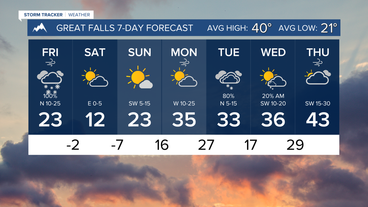
Snow is starting to move into much of north-central Montana this evening, creating hazardous driving conditions. Black Friday will be a very snowy day for a lot of the state. Blowing snow will also be an issue by early tomorrow morning.
Several inches of snow are possible across most lower elevations tonight and Friday, with major winter weather impacts expected in the mountains and in portions of north-central Montana.
Wind gusts will be approaching the 30-40 MPH mark through much of the state on Friday. This can create snow drifts on roads and cause whiteout conditions. Be very careful if you have to travel tomorrow!
Temperatures will be getting much colder throughout the day on Friday. By Saturday morning, lows will dip into the single digits above and below zero. It is going to be a frigidly cold weekend for much of the state.
We are tracking another storm system bringing snow by the middle of next week.
——————————————————————————————————————————
WEATHER ALERTS:
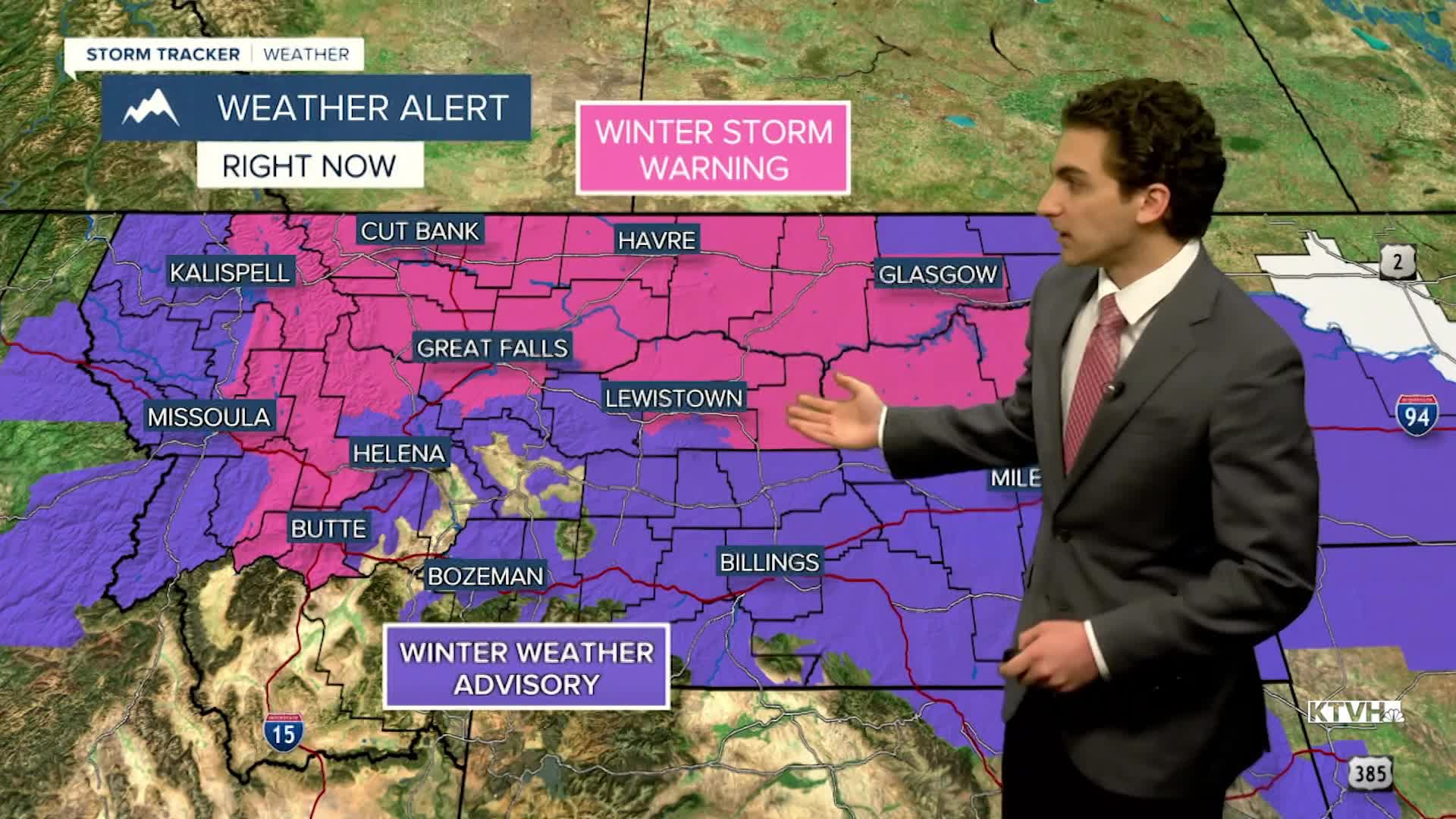
A WINTER STORM WARNING continues for Marias Pass, Polebridge, Bad Rock Canyon, Glacier National Park, Highway 83 Bigfork to Swan Lake, and Essex until 2 PM Friday
A WINTER STORM WARNING continues for the Montana Hi-Line adjacent to the Rocky Mountain Front until 5 PM Friday
A WINTER STORM WARNING continues forEastern Toole and Liberty; Southern Rocky Mountain Front; Southern High Plains; Eastern Pondera and Eastern Teton; Western and Central Chouteau County; Cascade County below 5000ft until 11 PM Friday
A WINTER STORM WARNING continues for Fergus County below 4500ft until 5 AM Saturday
A WINTER STORM WARNING continues for Central and Southeast Phillips; Central and Southern Valley; Garfield; McCone; Richland; Dawson; Northern Phillips; Southwest Phillips Counties until 5 AM Saturday
A WINTER STORM WARNING continues for Petroleum County until 5 AM Saturday
A WINTER STORM WARNING continues for Bears Paw Mountains and Southern Blaine, Hill County, and Northern Blaine County. The hazardous conditions could impact the Friday morning commute until 5 AM Saturday
A WINTER STORM WARNING has been issued for Georgetown Lake, Highway 200 Bonner to Greenough, Highway 83 Seeley Lake to Condon, MacDonald Pass, Homestake Pass, Butte, I-90 East Missoula to Bearmouth, and Highway 12 Garrison to Elliston from 2 AM Friday until 6 PM Saturday
A DENSE FOG ADVISORY continues for Central and Southeast Phillips, Daniels, Northern Phillips, Northern Valley, Sheridan, and Southwest Phillips Counties until 4 AM Friday
A DENSE FOG ADVISORY continues for Western Roosevelt County until 4 AM Friday
A WINTER WEATHER ADVISORY has been issued for Polson, the Flathead Valley, the Mission Valley, and Flathead Lake from 6 PM Thursday until 5 PM Friday
A WINTER WEATHER ADVISORY has been issued for the Kootenai/Cabinet Region, Bitterroot/Sapphire Mountains, Lower Clark Fork Region, and Missoula/Bitterroot Valleys from 11 PM Thursday until 5 PM Friday
A WINTER WEATHER ADVISORY has been issued for the Kootenai/Cabinet Region, Bitterroot/Sapphire Mountains, Lower Clark Fork Region, and Missoula/Bitterroot Valleys from 11 PM Thursday until 5 PM Friday
A WINTER WEATHER ADVISORY has been issued for Judith Gap and Southern Wheatland from 11 PM Thursday until 5 AM Saturday
A WINTER WEATHER ADVISORY has been issued for Musselshell, Northeastern Yellowstone, Treasure, Custer, and Northern Rosebud from 11 PM Thursday until 5 AM Saturday
A WINTER WEATHER ADVISORY has been issued for Daniels, Northern Valley, Prairie, Sheridan, and Wibaux Counties from 11 PM Thursday until 11 AM Saturday
A WINTER WEATHER ADVISORY has been issued for Eastern Roosevelt and Western Roosevelt Counties from 11 PM Thursday until 11 AM Saturday
A WINTER WEATHER ADVISORY has been issued for Upper Blackfoot and MacDonald Pass from midnight Thursday until 5 PM Friday
A WINTER WEATHER ADVISORY has been issued for Judith Basin County and Judith Gap; Gates of the Mountains; Little Belt and Highwood Mountains; Snowy and Judith Mountains; Helena Valley; Big Belt, Bridger and Castle Mountains; Elkhorn and Boulder Mountains; Gallatin Valley from midnight Thursday until 5 PM Friday
A WINTER WEATHER ADVISORY has been issued for the Madison River Valley from midnight Thursday until 5 AM Saturday
A WINTER WEATHER ADVISORY has been issued for Northern Stillwater; Golden Valley; Red Lodge Foothills; Northern Big Horn; Beartooth Foothills; Southeastern Carbon; Northern Sweet Grass; Bighorn Canyon; Northern Carbon; Melville Foothills; Southwestern Yellowstone from 5 AM Friday until 5 AM Saturday
A WINTER WEATHER ADVISORY has been issued for Livingston Area, Northern Park, and Paradise Valley from 5 AM Friday until 5 AM Saturday
A WINTER WEATHER ADVISORY has been issued for Fallon, Powder River, Carter, Southern Rosebud, and Southern Big Horn Counties from 5 AM Friday until 11 AM Saturday
——————————————————————————————————————————
Helena Temperature Records Today:
High: 61 (2017)
Low: -22 (1896)
AVG: 38/19
Great Falls Temperature Records Today:
High: 64 (1914)
Low: -24 (1985)
AVG: 40/21