


We are finally waking up to snow after last week's record warmth. Roads are slushy, so please be careful as you head out the door this morning.
MONDAY, FEBRUARY 9TH: Snow will continue through most of the morning. Roads are very slushy and slick. Accumulation will be around 1-3 inches in Helena, depending on your elevation. As the main band of snow moves out by noon, partly cloudy skies will give way to some convective snow showers over the mountains. These may be locally intense at times.
Some mountain ranges could see near 10-20 inches of snow. This will do wonders for the mountain snowpack.
Highs will only reach the 30s and 40s, a huge change from last week.
As we head into the nighttime, snow and rain will move out of the state, and skies will clear.
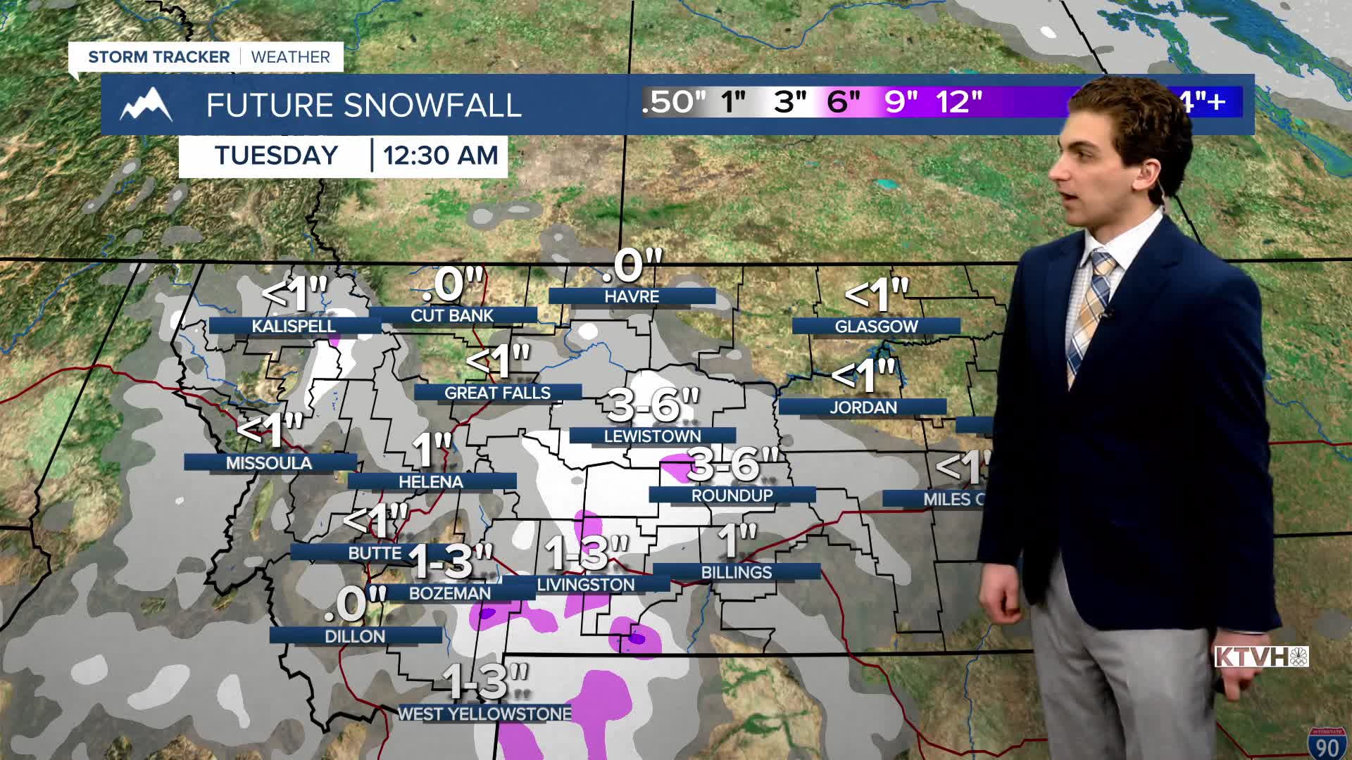
TUESDAY, FEBRUARY 10TH: Temperatures will dip below freezing in the morning, creating a risk for ice to form with melted snow from Monday. Be careful on the roads. Colder air will be trapped in the valleys, so highs will only reach the upper 30s. Highs in the plains will reach the 40s.
WEDNESDAY, FEBRUARY 11TH: A cutoff low-pressure system will pass to our south, bringing snow back to states like Colorado, Utah, Wyoming, and Idaho. Snow will make its way into southwest Montana and possibly some isolated showers as far north as Helena. But expect a mostly dry day for the majority of us. Highs will reach the 30s and 40s again under party to mostly sunny skies.
THURSDAY, FEBRUARY 11TH: Thursday will be a really nice day. Highs approach the 40s and low 50s across the state under mostly sunny skies.
LONG-RANGE FORECAST: Temperatures will be above average towards the end of the week, but more rain and snow are expected by the weekend and early next week.
——————————————————————————————————————————
WEATHER ALERTS:
A WINTER STORM WARNING continues for the Absaroka/Beartooth Mountains and Crazy Mountains until 5 PM Monday
A WINTER WEATHER ADVISORY continues for Georgetown Lake, Homestake Pass, Highway 12 Garrison to Elliston, MacDonald Pass, and Butte until 8 AM Monday
A WINTER WEATHER ADVISORY continues for Lolo Pass and Highway 93 Sula to Lost Trail Pass until 11 AM Monday
A WINTER WEATHER ADVISORY continues for Evaro Hill and I-90 Lookout Pass to Haugan until 11 AM Monday
A WINTER WEATHER ADVISORY continues for Marias Pass and Glacier National Park until 11 AM Monday
A WINTER WEATHER ADVISORY continues for the Highwood, Little Belt, Judith, and Snowy Mountains, Southern Rocky Mountain Front, Northwest Beaverhead County, and Gallatin and Madison County Mountains and Centennial Mountains until 11 AM Monday
A WINTER WEATHER ADVISORY continues for portions of central and north central Montana until 11 AM Monday
A WINTER WEATHER ADVISORY continues for the Golden Valley, Judith Gap, Musselshell, Southern Wheatland, and Melville Foothills until 2 PM Monday
A WINTER WEATHER ADVISORY continues for northern Stillwater and northern Sweet Grass Counties until 2 PM Monday
——————————————————————————————————————————
Helena Temperature Records Today:
High: 57 (1951)
Low: -35 (1933)
AVG: 35/16
Great Falls Temperature Records Today:
High: 63 (2016)
Low: -35 (1939)
AVG: 36/15
