


Severe driving conditions have been reported on parts of I-15 between Clancy and Elk Park. Please be careful. Remember to keep your distance between other drivers (and plows). Low gear and take it slow. I would avoid traveling through that stretch of I-15 unless it is absolutely necessary!
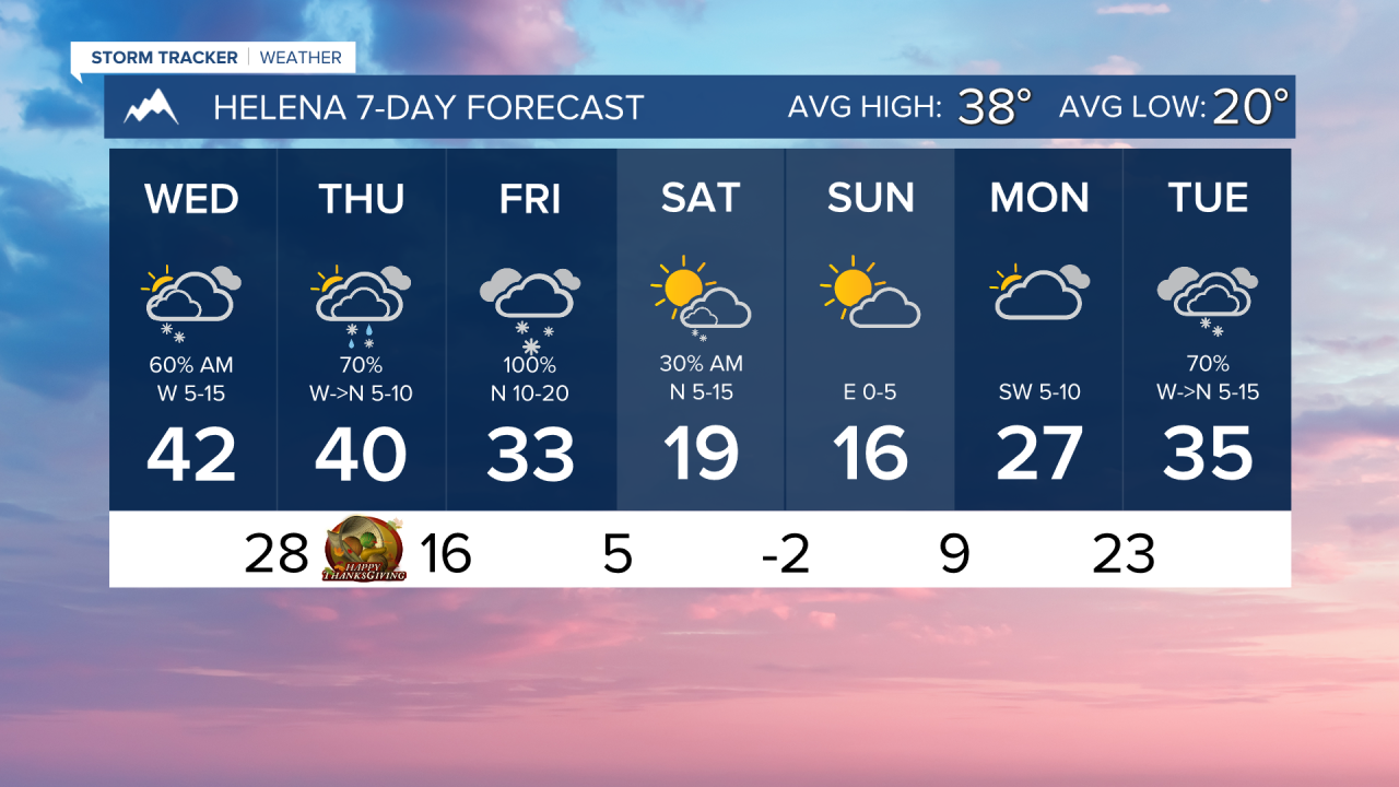
A more significant winter weather system will move into the state on Thanksgiving. It will start as a rain/snow mix in Helena in the morning. We will see the conversion over to heavy snow by Thanksgiving night. Several inches of snow are possible across most lower elevations Thursday and Friday, with major winter weather impacts expected in the mountains and in parts of north-central Montana.
Major impact to travel across the state should be expected on Thanksgiving night and all throughout the day on Black Friday.
Although the weekend is dry with high pressure building over the state, it will be very cold. Highs will only reach the teens and 20s, while lows dip into the single digits above and below zero. Wind chills could reach the teens below zero.
We are tracking another possible storm impacting the state near the middle of next week.
——————————————————————————————————————————
WEATHER ALERTS:
A WINTER WEATHER ADVISORY continues for the Elkhorn and Boulder Mountains and Upper Blackfoot and MacDonald Pass until 10 AM Wednesday
A WINTER WEATHER ADVISORY continues for the Big Belt, Bridger and Castle Mountains, and Little Belt and Highwood Mountains until 10 AM Wednesday
A WINTER WEATHER ADVISORY continues for Essex, Marias Pass, Glacier National Park, Bad Rock Canyon, Polebridge, and Highway 83 Bigfork to Swan Lake until 11 AM Wednesday
A WINTER WEATHER ADVISORY continues for Highway 83 Seeley Lake to Condon, Highway 200 Bonner to Greenough, and I-90 East Missoula to Bearmouth until 11 AM Wednesday
A WINTER WEATHER ADVISORY continues for Butte, Georgetown Lake, Homestake Pass, MacDonald Pass, and Highway 12 Garrison to Elliston until 11 AM Wednesday
A WINTER WEATHER ADVISORY continues for Highway 11 Pierce to Headquarters, Dixie, Elk City, Highway 12 Lowell to Lolo Pass, Elk River, and Pierce until 11 AM Wednesday
A WINTER WEATHER ADVISORY continues for Highway 56 Bull Lake Road, Highway 93 Eureka to Whitefish, Highway 2 Kalispell to Libby, and Highway 37 Eureka to Libby until 11 AM Wednesday
A WINTER WEATHER ADVISORY continues for the Mission Valley, Polson, Flathead Lake, and Flathead Valley until 11 AM Wednesday
A WINTER WEATHER ADVISORY continues for I-90 Lookout Pass to Haugan, Highway 200 Thompson Falls to Plains, Highway 200 Trout Creek to Heron, and Evaro Hill until 11 AM Wednesday
A WINTER WEATHER ADVISORY continues for the Missoula and Bitterroot Valley until 11 AM Wednesday
A WINTER WEATHER ADVISORY continues for Highway 93 Sula to Lost Trail Pass and Lolo Pass until 11 AM Wednesday
A DENSE FOG ADVISORY continues for Eastern Toole and Liberty Counties, Hill County, and Northern Blaine County until 11 AM Wednesday
A DENSE FOG ADVISORY continues for Central and Southeast Phillips, Central and Southern Valley, and Roosevelt Counties until noon Wednesday
A WINTER STORM WATCH has been issued for the East Glacier Park Region-Northern High Plains-Eastern Glacier, Western Toole, and Central Pondera-Eastern Toole and Liberty- Southern Rocky Mountain Front-Southern High Plains-Eastern Pondera and Eastern Teton-Western and Central Chouteau County- Cascade County below 5000ft from Thursday afternoon until Friday afternoon
A WINTER STORM WATCH has been issued for Essex, Marias Pass, Glacier National Park, Bad Rock Canyon, Polebridge, and Highway 83 Bigfork to Swan Lake from Thursday afternoon until Friday afternoon
——————————————————————————————————————————
Helena Temperature Records Today:
High: 66 (2017)
Low: -18 (1985)
AVG: 38/20
Great Falls Temperature Records Today:
High: 67 (2017)
Low: -21 (1985)
AVG: 40/21