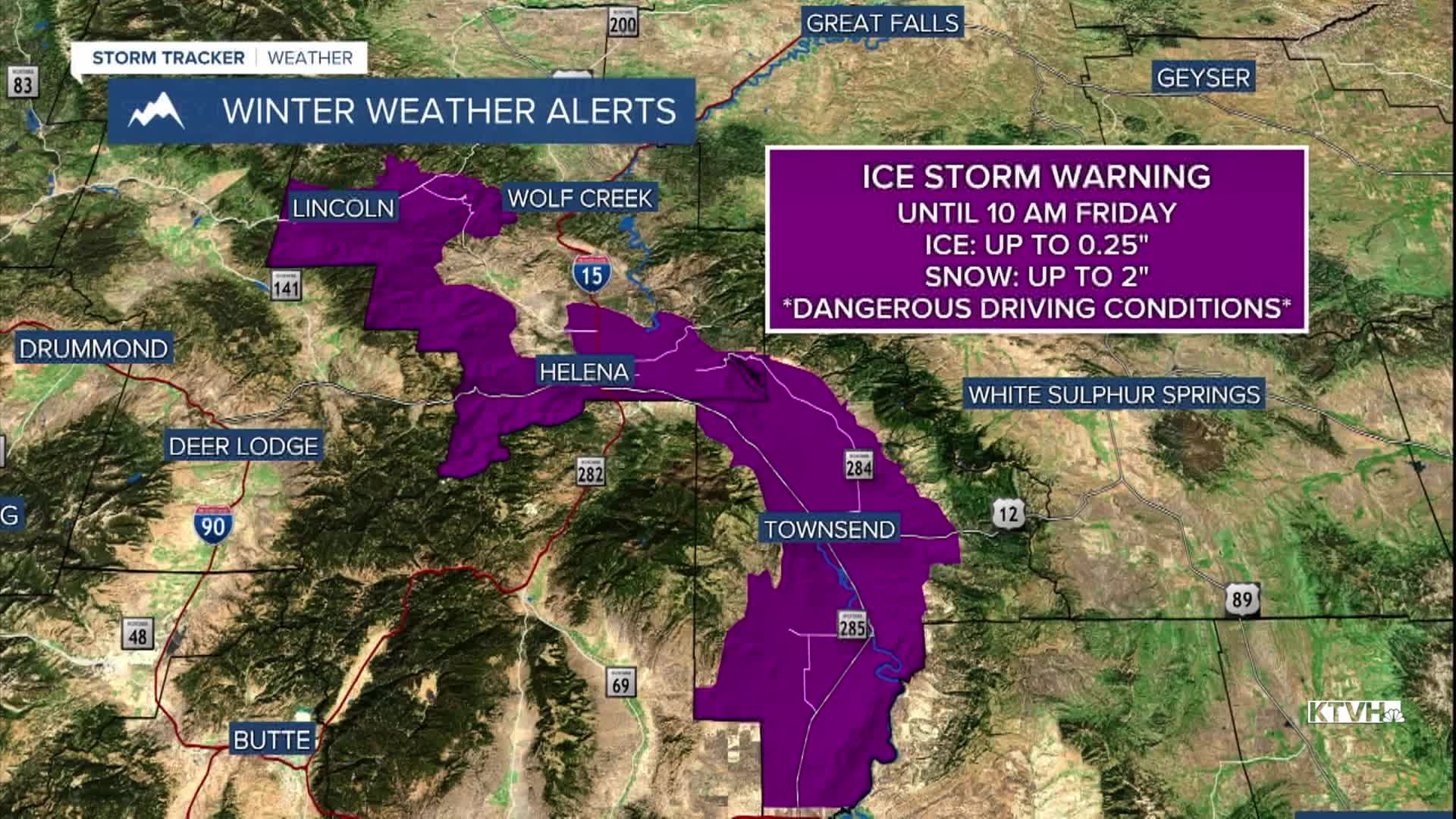


A rare Ice Storm Warning has been issued by the National Weather Service for Helena, Lincoln, and Townsend for significant ice accumulation that can reach up to a quarter of an inch. This will make travel this morning very difficult in the area. Remember to fully scrape your windshield, drive slowly, and leave plenty of space between you and the driver ahead.
Icy conditions are being reported in the Bozeman and Butte areas as well. Parts of I-15 and I-90 are a wintry mess this morning. For the latest road conditions across the state, check out the Montana Department of Transportation Traveler Information Map.
In other parts of the state, heavy snow is falling and will continue to accumulate through most of the day in areas like Lewistown and Havre. The heaviest snowband is situated over Great Falls this morning, but it will push northeastward throughout the day. Helena will see the snow come to an end around 9-10 AM.
Another brief round of freezing rain and snow could move back into the Helena/Great Falls/Lewistown area early Saturday morning, but it will not be as impactful as today. By Saturday afternoon, everybody should be dry for the rest of the weekend.
Extreme Cold with wind chills as low as -40° are occurring in the plains this morning. Temperatures will only reach the single digits and teens for most of that area. Helena should warm above freezing this afternoon before dropping below 32° later tonight.
Temperatures will continue to warm this weekend and into early next week, with the wind picking up once again. We will be tracking another high wind event Monday through Wednesday.
Another storm system will bring more rain and snow, mainly to the mountains, towards the middle of next week.
——————————————————————————————————————————
WEATHER ALERTS:
An ICE STORM WARNING continues for Canyon Ferry Area, Helena Valley, Upper Blackfoot, and MacDonald Pass until 10 AM Friday
An EXTREME COLD WARNING continues for Daniels, Northern Valley, and Sheridan Counties until noon Friday
A WINTER STORM WARNING continues for The Highwood, Little Belt, Judith, and Snowy Mountains, and The Continental Divide along the Rocky Mountain Front until 6 PM Friday
A WINTER STORM WARNING continues for the Crazy Mountains until 8 PM Friday
A WINTER STORM WARNING continues for portions of south central and southeast Montana until 8 PM Friday
A WINTER STORM WARNING continues for Golden Valley, Judith Gap, Musselshell, Southern Wheatland, and Northeastern Yellowstone until 11 PM Friday
A WINTER STORM WARNING continues for Fergus County below 4500ft and Judith Basin County and Judith Gap until 5 AM Saturday
A WINTER STORM WARNING continues for Eastern Toole and Liberty Counties, Hill County, Northern Blaine County, Western and Central Chouteau County, and the Bears Paw Mountains and Southern Blaine until 6 AM Saturday
A WINTER STORM WARNING continues for a portion of northeast Montana until 8 AM Saturday
A WINTER STORM WARNING continues for Treasure, Custer, and Northern Rosebud Counties until 8 AM Saturday
An AVALANCHE WARNING continues for the Beartooth Mountains until 5:30 AM Saturday
A FLOOD WARNING continues for the Fisher River Near Libby, affecting Lincoln County until further notice
A COLD WEATHER ADVISORY continues for Eastern Glacier, Western Toole, and Central Pondera Counties, Eastern Toole and Liberty Counties, Hill County, and Northern Blaine County until 10 AM Friday
A WINTER WEATHER ADVISORY continues for Central and Southern Valley, Dawson, Roosevelt, McCone, Northern Phillips, Richland, and Wibaux Counties until 1 PM Friday
A WINTER WEATHER ADVISORY continues for Canyon Ferry Area, Helena Valley, and Upper Blackfoot and MacDonald Pass until 10 AM Friday
A WINTER WEATHER ADVISORY continues for the Interstate 90 Corridor between Bozeman and Whitehall, and Elkhorn and Boulder Mountains until 10 AM Friday
A WINTER WEATHER ADVISORY continues for the Bighorn Canyon and Northern Carbon until noon Friday
A WINTER WEATHER ADVISORY continues for the Pryor/Northern Bighorn Mountains until noon Friday
A WINTER WEATHER ADVISORY continues for the Big Belt, Bridger and Castle Mountains, Gates of the Mountains, Meagher County Valleys, Cascade County below 5000ft, and Southern High Plains until 6 PM Friday
A WINTER WEATHER ADVISORY continues for the Livingston Area and Northern Park County until 9 AM Friday
A WINTER WEATHER ADVISORY continues for the Interstate 15 Corridor north of Power, and Northern High Plains until 5 AM Saturday
A WINTER WEATHER ADVISORY continues for Bad Rock Canyon, Glacier National Park, Marias Pass, Essex, Highway 83 Bigfork to Swan Lake, and Polebridge until 5 AM Saturday
A WINTER WEATHER ADVISORY continues for Daniels, Northern Valley, Richland, and Roosevelt Counties until 8 AM Saturday
A WINTER WEATHER ADVISORY continues for the Livingston Area and Northern Park County until 8 AM Saturday
——————————————————————————————————————————
Helena Temperature Records Today:
High: 62 (2014)
Low: -23 (1922)
AVG: 33/15
Great Falls Temperature Records Today:
High: 63 (2014)
Low: -32 (1922)
AVG: 36/17


