


A band of very heavy snow will be moving through the state this evening. This will bring a quick burst of snow and gusty winds. Snow squalls are possible to form around our area.
Areas like Helena and Great Falls will receive the heavy burst of snow through the evening commute hours. Be careful out on the roads, especially in the higher terrain, as some areas could experience white-out conditions for a short period of time.
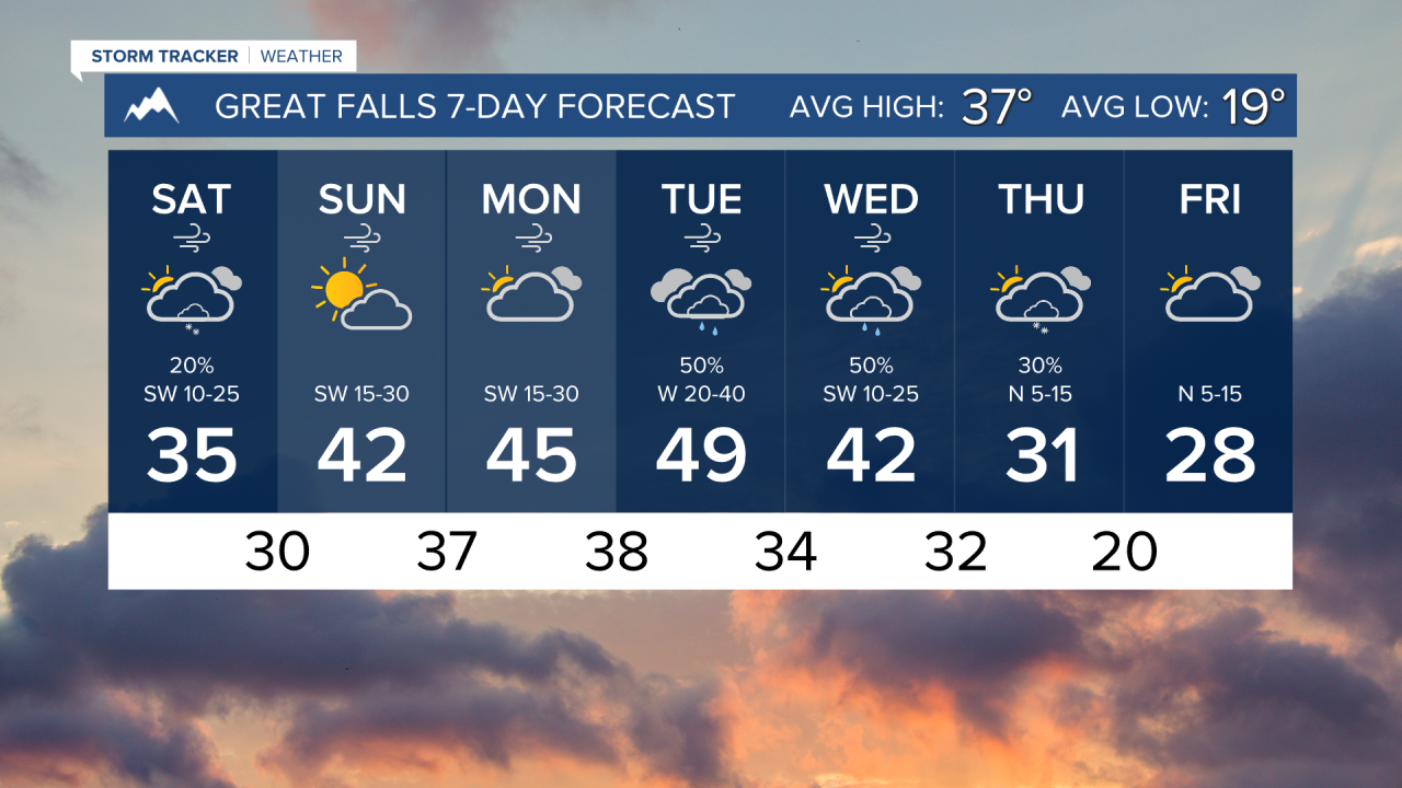
The wind will remain gusty through most of the week near the Continental Divide. In Helena, expect winds to peak between 10-20 MPH through the weekend, with isolated gusts around 30 MPH.
The Mountains will have snow showers around for both Saturday and Sunday, but expect drier and slightly warmer conditions in the valley and plains.
A setup for a strong wind event is looking likely on Monday night into Tuesday.
Another round of moisture will move over the state on Tuesday and Wednesday, bringing more mountain snow and lower elevation rain.
——————————————————————————————————————————
WEATHER ALERTS:
A WINTER STORM WARNING continues for the Absaroka/Beartooth Mountains and Crazy Mountains until 2 PM Saturday
A WINTER STORM WARNING continues for the Big Belt, Bridger and Castle Mountains, Little Belt and Highwood Mountains, and Gallatin and Madison County Mountains and Centennial Mountains until 2 PM Saturday
A WINTER STORM WARNING continues for Highway 11 Pierce to Headquarters, Highway 12 Lowell to Lolo Pass, Elk River, Elk City, Pierce, and Dixie until 4 PM Saturday
A WINTER STORM WARNING continues for Highway 93 Sula to Lost Trail Pass and Lolo Pass until 5 PM Saturday
A WINTER STORM WARNING continues for Highway 83 Seeley Lake to Condon, I-90 East Missoula to Bearmouth, and Highway 200 Bonner to Greenough until 5 PM Saturday
A WINTER STORM WARNING continues for I-90 Lookout Pass to Haugan, Highway 200 Thompson Falls to Plains, Highway 200 Trout Creek to Heron, and Evaro Hill until 5 PM Saturday
A WINTER STORM WARNING continues for Northwest Beaverhead County until 5 PM Saturday
A WINTER WEATHER ADVISORY continues for Highway 2 Kalispell to Libby, Highway 37 Eureka to Libby, Highway 93 Eureka to Whitefish, and Highway 56 Bull Lake Road until 11 PM Friday
A WINTER WEATHER ADVISORY continues for Dawson, Eastern Roosevelt, and Richland Counties until 5 AM Friday
A WINTER WEATHER ADVISORY continues for the Missoula and Bitterroot Valley until 11 AM Friday
A WINTER WEATHER ADVISORY continues for Highway 12 Garrison to Elliston, MacDonald Pass, Butte, Georgetown Lake, and Homestake Pass until 11 AM Friday
A WINTER WEATHER ADVISORY continues for the Elkhorn and Boulder Mountains until 11 AM Friday
A WINTER WEATHER ADVISORY continues for the Gallatin Valley until 11 AM Friday
A WINTER WEATHER ADVISORY continues for the Flathead Valley, Mission Valley, Polson, and Flathead Lake until 11 AM Friday
A WINTER WEATHER ADVISORY continues for the Pryor/Northern Bighorn Mountains until 2 PM Friday
A WINTER WEATHER ADVISORY continues for Absaroka Mountains and Yellowstone National Park until 2 PM Saturday
A WINTER WEATHER ADVISORY continues for Essex, Marias Pass, Polebridge, Highway 83 Bigfork to Swan Lake, Glacier National Park, and Bad Rock Canyon until 5 PM Saturday
A WINTER WEATHER ADVISORY continues for the Continental Divide along the Rocky Mountain Front until 9 PM Saturday
A WINTER WEATHER ADVISORY has been issued for portions of central and north central Montana from 8 PM Friday until 5 AM Saturday
A WINTER WEATHER ADVISORY has been issued for most of northeast Montana from 8 PM Friday until noon Saturday
——————————————————————————————————————————
Helena Temperature Records Today:
High: 64 (2023)
Low: -28 (1972)
AVG: 35/17
Great Falls Temperature Records Today:
High: 69 (1939)
Low: -26 (2013)
AVG: 37/19