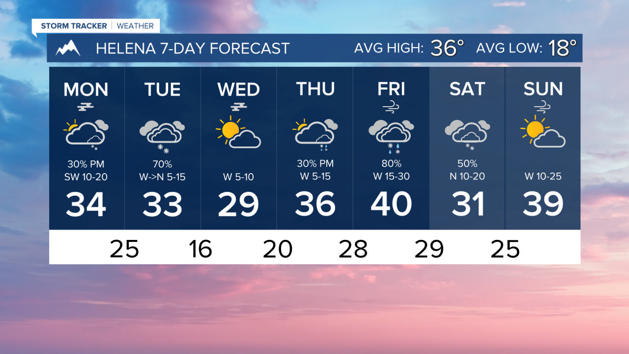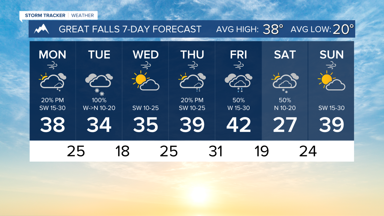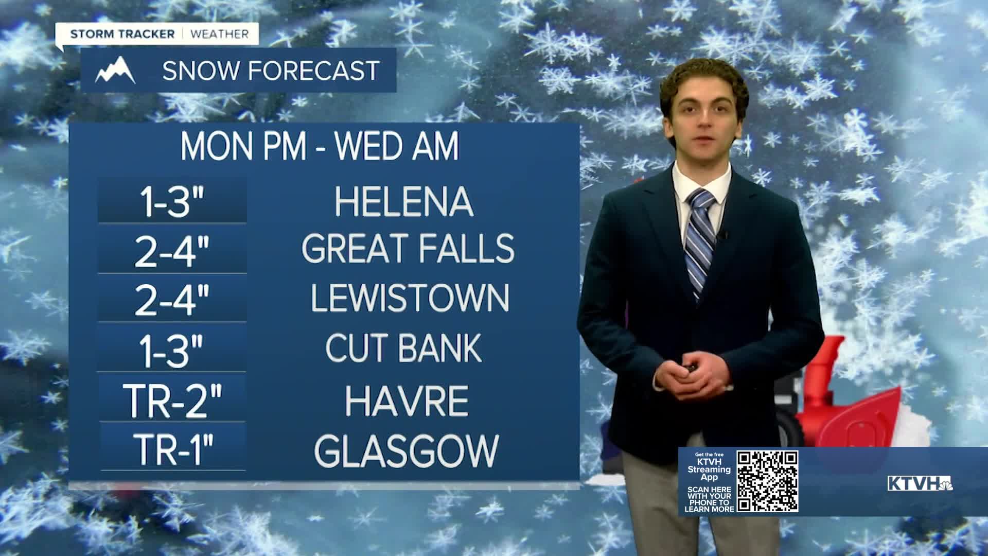


Another round of snow is on the way tonight and tomorrow. This will mainly impact higher elevations, but some light snow accumulation is possible in the Helena area.
Very cold air has stuck around this morning, with the Helena Valley in the single digits. There is an inversion layer that allowed some fog to form overnight. The wind will begin to pick up this afternoon, blowing the fog out and warming temperatures to the low to mid-30s.
Some snow showers will move into the area by about 4 to 5 PM. They will mainly impact the mountains tonight, but a few flakes are possible in the lower elevations. Most of our snow will come in the morning and early afternoon on Tuesday. Winds will be out of the west until mid-to-late morning tomorrow, then turn north by the afternoon. Once these winds switch directions, snow will be more favored for lower elevations.
Generally speaking, expect about 1-3 inches across lower elevations, with isolated instances of 4-6" in the mountains.
The wind will remain gusty through most of the week near the Continental Divide. This will create opportunities for blowing and drifting snow, especially near the Rocky Mountain Front.
The wind will keep temperatures near to slightly above average this week. Highs will be in the 30s and 40s for most of the state.
Another round of wintry weather will come through the state on Friday. Details are still a little murky on this system, but I expect more of a rain/snow mix with slightly warmer temperatures initially. This could lead to icing heading into Saturday. We will keep watching the evolution of this system throughout the week.
——————————————————————————————————————————
WEATHER ALERTS:
A WINTER WEATHER ADVISORY has been issued for Highway 93 Eureka to Whitefish, Highway 37 Eureka to Libby, Highway 56 Bull Lake Road, and Highway 2 Kalispell to Libby from 1 PM Monday until noon Tuesday
A WINTER WEATHER ADVISORY has been issued for the Flathead Valley, Polson, Mission Valley, and Flathead Lake from 2 PM Monday until noon Tuesday
A WINTER WEATHER ADVISORY has been issued for I-90 Lookout Pass to Haugan, Highway 200 Trout Creek to Heron, Highway 200 Thompson Falls to Plains, and Evaro Hill from 2 PM Monday until noon Tuesday
A WINTER WEATHER ADVISORY has been issued for Glacier National Park, Bad Rock Canyon, Marias Pass, Highway 200 Bonner to Greenough, I-90 East Missoula to Bearmouth, Essex, Polebridge, Highway 83 Bigfork to Swan Lake, and Highway 83 Seeley Lake to Condon from 2 PM Monday until 5 PM Tuesday
A WINTER WEATHER ADVISORY has been issued for the Continental Divide along the Rocky Mountain Front from 5 PM Monday until 11 PM Tuesday
A WINTER WEATHER ADVISORY has been issued for the Bitterroot Valley and Missoula from 8 PM Monday until 2 PM Tuesday
A WINTER WEATHER ADVISORY has been issued for Lolo Pass and Highway 93 Sula to Lost Trail Pass from 8 PM Monday until 5 PM Tuesday
A WINTER WEATHER ADVISORY has been issued for the Highwood, Little Belt, Judith, and Snowy Mountains, Big Belt, Bridger and Castle Mountains, and Gallatin and Madison County Mountains and Centennial Mountains from 11 PM Monday until 5 AM Wednesday
A WINTER WEATHER ADVISORY has been issued for Cascade County below 5000ft, Judith Basin County and Judith Gap, Fergus County below 4500ft, Upper Blackfoot and MacDonald Pass, Gates of the Mountains, and the Helena Valley from 5 AM Tuesday until 5 AM Wednesday
A WINTER WEATHER ADVISORY has been issued for Northwest Beaverhead County from 5 PM Monday until 11 PM Tuesday
A WINTER WEATHER ADVISORY has been issued for Northern Big Horn, Southern Big Horn, Carter, Powder River, and Southern Rosebud from 5 AM Tuesday until 5 AM Wednesday
A WINTER WEATHER ADVISORY has been issued for Pryor/Northern Bighorn Mountains from 11 AM Tuesday until 5 AM Wednesday
A WINTER WEATHER ADVISORY has been issued for the Bighorn Canyon from 5 PM Tuesday until 5 AM Wednesday
A WINTER WEATHER ADVISORY has been issued for the Beartooth Foothills and Red Lodge Foothills from 5 PM Tuesday until 5 AM Wednesday
——————————————————————————————————————————
Helena Temperature Records Today:
High: 70 (2021)
Low: -25 (1985)
AVG: 36/18
Great Falls Temperature Records Today:
High: 69 (2021)
Low: -29 (1985)
AVG: 38/20