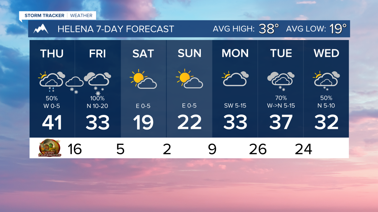
Thanksgiving morning is mostly quiet, but by this evening, conditions will begin to change. Heavy snow is forecasted for a good chunk of the state.
A significant winter weather system has started to move in on this Thanksgiving Thursday. A stray shower is possible in Helena this morning. Precipitation will start out as a rain/snow mix this evening. We will see the conversion over to snow by late tonight.
Several inches of snow are possible across most lower elevations Thursday and Friday, with major winter weather impacts expected in the mountains and in portions of north-central Montana. Blowing snow will be a concern on Friday.
Temperatures will be getting much colder throughout the day on Friday. By Saturday morning, lows will dip into the single digits above and below zero. It is going to be a frigidly cold weekend for much of the state.
We are tracking another storm system bringing snow by the middle of next week.
——————————————————————————————————————————
WEATHER ALERTS:
A WINTER STORM WARNING has been issued for the Montana Hi-Line adjacent to the Rocky Mountain Front from 2 PM Thursday until 5 PM Thursday
A WINTER WEATHER ADVISORY has been issued for Judith Basin County and Judith Gap-Fergus County below 4500ft- Gates of the Mountains-Little Belt and Highwood Mountains-Snowy and Judith Mountains-Helena Valley-Big Belt, Bridger and Castle Mountains-Elkhorn and Boulder Mountains-Gallatin Valley- Including the following locations: Montana City, Geyser, Windham, Helena, Neihart, Bozeman Pass, Wickes, Corbin, Boulder, Clancy, Homestake Pass, Bozeman, Hilger, Canyon Creek, Maudlow, Raynesford, Gallatin Gateway, Hobson, Craig, Stanford, Battle Ridge Pass, Trident, Wolf Creek, Lewistown, Benchland, Elk Park Pass, Monarch, Moccasin, Deep Creek Pass, and Kings Hill Pass from midnight Thursday until 11 PM Friday
A WINTER WEATHER ADVISORY has been issued for the Kootenai/Cabinet Region, Bitterroot/Sapphire Mountains, Lower Clark Fork Region, and Missoula/Bitterroot Valleys from midnight Thursday until 5 PM Friday
A WINTER STORM WATCH has been issued for a portion of north central Montana from Thursday afternoon until Friday afternoon
A WINTER STORM WATCH has been issued for the Bears Paw Mountains and Southern Blaine, Hill County, and Northern Blaine County from Thursday afternoon until Friday afternoon
A WINTER STORM WATCH has been issued for the Upper Blackfoot and MacDonald Pass from Thursday afternoon until Friday afternoon
A WINTER STORM WATCH has been issued for Highway 83 Bigfork to Swan Lake, Essex, Bad Rock Canyon, Marias Pass, Glacier National Park, and Polebridge from Thursday afternoon until Friday afternoon
A WINTER STORM WATCH has been issued for MacDonald Pass, Highway 83 Seeley Lake to Condon, Butte, Highway 12 Garrison to Elliston, Homestake Pass, Highway 200 Bonner to Greenough, I-90 East Missoula to Bearmouth, Flathead Valley, Mission Valley, Polson, Georgetown Lake, and Flathead Lake from Thursday afternoon until Friday afternoon
A WINTER STORM WATCH has been issued for a portion of northeast Montana from Thursday afternoon until Friday night
——————————————————————————————————————————
Helena Temperature Records Today:
High: 61 (2017)
Low: -22 (1896)
AVG: 38/19
Great Falls Temperature Records Today:
High: 64 (1914)
Low: -24 (1985)
AVG: 40/21