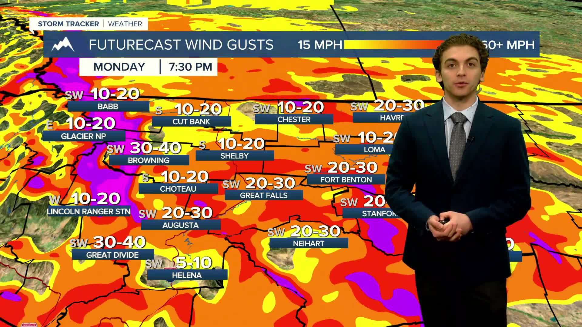


A majority of the state east of the Continental Divide will deal with powerful wind gusts today and Tuesday.
Maximum gusts near the Rocky Mountain Front will be near 80 MPH, with some isolated spots exceeding that. Winds will be sustained between 30-45 MPH with gusts near 60 MPH for the rest of the area.
Heavy rain and mountain snow are expected west of the divide over the coming days.
Lower elevations will reach above-average temperatures, in the 40s and low 50s, through Wednesday
A surface cold front will work into the plains on Wednesday afternoon. This will drop temperatures significantly and allow the plains to pick up a few inches of snow Thursday-Saturday.
——————————————————————————————————————————
WEATHER ALERTS:
A HIGH WIND WARNING continues for Judith Basin County and Judith Gap until 3 PM Tuesday
A WIND ADVISORY continues for the Beartooth Foothills and Livingston Area until 5 PM Monday
A HIGH WIND WARNING has been issued for the Rocky Mountain Front and adjacent foothills and plains, the Interstate 15 Corridor north of Power, Eastern Toole and Liberty Counties, Cascade County below 5000ft, Upper Blackfoot and MacDonald Pass, and Gates of the Mountains from 2 PM Monday until 10 AM Tuesday
A HIGH WIND WARNING has been issued for the Madison River Valley from 2 PM Monday until 10 AM Tuesday
A HIGH WIND WARNING has been issued for the Beartooth Foothills and Livingston Area from 5 PM Monday until 11 AM Tuesday
A HIGH WIND WARNING has been issued for the Absaroka/Beartooth Mountains and Crazy Mountains from 5 PM Monday until 11 AM Tuesday
A WINTER STORM WARNING has been issued for the Absaroka/Beartooth Mountains and Crazy Mountains from 5 PM Monday until 5 PM Wednesday
A HIGH WIND WARNING has been issued for the Bears Paw, Highwood, Little Belt, and Snowy Mountains, Hill County, Northern Blaine County, Western and Central Chouteau County, Fergus County below 4500ft, Big Belt, Bridger and Castle Mountains, and Meagher County Valleys from 6 PM Monday until 3 PM Tuesday
A HIGH WIND WARNING has been issued for all of northeast Montana from 11 PM Monday until 5 PM Tuesday
A HIGH WIND WARNING has been issued for Judith Gap, Southern Wheatland, Melville Foothills, and Northern Sweet Grass from 11 PM Monday until 5 PM Tuesday
A WIND ADVISORY has been issued for the Kootenai/Cabinet Region and Lower Clark Fork Region from 8 PM Monday until 8 AM Tuesday
A WIND ADVISORY has been issued for the Flathead/Mission Valleys from 11 PM Monday until 8 AM Tuesday
A WIND ADVISORY has been issued for the West Glacier Region from 11 PM Monday until 11 AM Tuesday
A WINTER WEATHER ADVISORY has been issued for all of northeast Montana from 11 PM Monday until 5 PM Tuesday
An AVALANCHE WATCH has been issued for the Selkirk, West and East Cabinet Mountains, and Bitterroot Mountains from Monday morning until Monday afternoon
A HIGH WIND WATCH has been issued for portions of central, south central, and southeast Montana from late Monday until Tuesday afternoon
A FLOOD WATCH has been issued for Mineral County from Monday afternoon until Thursday morning
——————————————————————————————————————————
Helena Temperature Records Today:
High: 60 (1939)
Low: -35 (1972)
AVG: 34/16
Great Falls Temperature Records Today:
High: 63 (2020)
Low: -36 (1972)
AVG: 37/18


