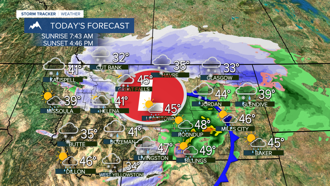


Wintry weather, including snow, ice, and wind, will impact Montana today with a storm system moving through. This is just the beginning of a colder and snowier pattern set to last into the beginning of December
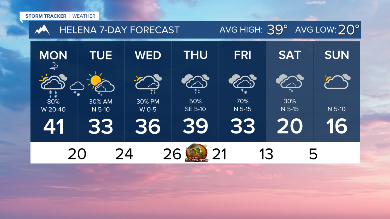
Lower elevations will see a rain/snow mix converging over to mostly snow. Ground temperatures are still a little warm, so we don't expect to see significant accumulation in Helena. An area of light snow is expected to move over the capital city Monday night and Tuesday morning. Up to an inch of snow is possible for most of the valley.
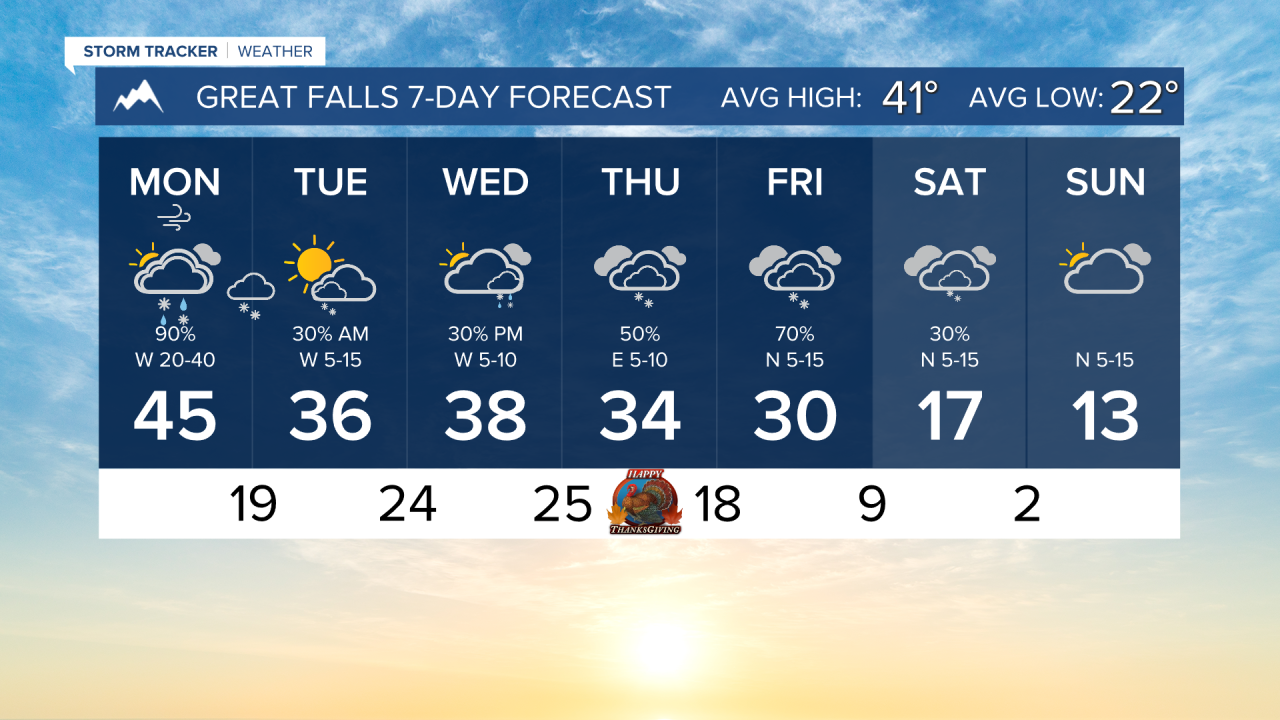
The Hi-Line and the international border are expected to receive the most snow with this system, at least for the lower elevations. Colder temperatures and more consistent precipitation falling throughout the day will create icy and snow-covered roads. Isolated instances of 5" of accumulation can occur.
Glacier National Park and the Continental Divide, as well as the Big Belts, Little Belts, Bear Paw, Sweet Grass Hills, and the Beartooth Mountains, are expected to pick up the most snow, with some higher peaks exceeding 1 foot of fresh powder. Going to be good for those ski areas! Be careful traveling over mountain passes!
Highs in the 30s will be common through the rest of this workweek, with another storm system coming in for Thanksgiving and lasting through Friday.
Very cold air will come in for the weekend. We are expecting highs in the teens and twenties with lows in the single digits.
——————————————————————————————————————————
WEATHER ALERTS:
A WINTER WEATHER ADVISORY continues for Highway 93 Sula to Lost Trail Pass, Highway 12 Powell to Lolo Pass, Lolo Pass, and Dixie until noon Monday
A WINTER WEATHER ADVISORY continues for Eastern Glacier, Western Toole, and Central Pondera Counties, and Eastern Toole and Liberty Counties until noon Monday
A WINTER WEATHER ADVISORY continues for Polebridge, Highway 83 Bigfork to Swan Lake, Glacier National Park, Marias Pass, Bad Rock Canyon, and Essex until 11 PM Monday
A WINTER WEATHER ADVISORY continues for Hill County and Northern Blaine County until 11 PM Monday
A WINTER WEATHER ADVISORY continues for the Big Belt, Bridger and Castle Mountains and Little Belt and Highwood Mountains until 11 PM Monday
A WINTER WEATHER ADVISORY continues for the Bears Paw Mountains and Southern Blaine until 11 PM Monday
A WINTER WEATHER ADVISORY continues for the Continental Divide along the Rocky Mountain Front until 11 PM Monday
A WINTER WEATHER ADVISORY continues for Wibaux County until 5 AM Tuesday
A WINTER WEATHER ADVISORY continues for Wolf Point, Opheim, Frazer, Plentywood, Medicine Lake, Hinsdale, Sidney, Zortman, Malta, Scobey, Saco, Fort Peck, Fairview, Glasgow, Circle, Whitewater, Culbertson, Poplar, Richey, and Glendive until 5 AM Tuesday
A WINTER WEATHER ADVISORY has been issued for Carter and Fallon Counties from 2 PM Monday until 11 AM Tuesday
——————————————————————————————————————————
Helena Temperature Records Today:
High: 63 (1986)
Low: -17 (1880)
AVG: 39/20
Great Falls Temperature Records Today:
High: 65 (1933)
Low: -21 (2010)
AVG: 41/22